[ pages: 1-23 ... 24-39 ... 40-59 ... 60-85 ... plates ... index ]

24   University of Texas Bulletin

THE GEOLOGICAL SECTION

  The marine formations found in Tarrant County, as already stated, are those of the Cretaceous System. In addition there are alluvial and terrace deposits of the Cenozoic. In the following table these formations are listed in order, the oldest formations being placed at the bottom of the table. In the second column is given the probable equivalence of the terms here used as applied to other sections in Central Texas, as given in Bulletin 44 of the Bureau of Economic Geology. Of the formations here listed, the oldest actually exposed at the surface in Tarrant County is the Paluxy. The older formations, however, are penetrated in well drilling.

TABLE OF GEOLOGIC FORMATIONS OF TARRANT COUNTY

Tarrant County Section

Cenozoic and Recent...........
Eagleford...............................
Woodbine.............................
Grayson    }..........................
Mainstreet} 
Pawpaw          }
Weno               }
Denton            }.....................
Fort Worth      }       
Duck Creek     } 
Kiamitia           }
Edwards                }
Comanche Peak    }...............
Goodland              }
Walnut................................... 
Paluxy ...................................
Glenrose................................
Trinity ...................................
Pennsylvanian......................
Central Texas Section

Cenozoic and Recent.
Eagleford.
Buda (?)
Del Rio.


Georgetown.


{Edwards.
{Comanche Peak.

Walnut.
Paluxy.
Glenrose.
Travis Peak.
.................

  l In this, tabulated statement of formations the Woodbine of Northern Texas appears as the equivalent of the Buda of Central Texas. Although in accordance with present usage, the authors wish to express reserve with regard to the equivalence of the Woodbine in the Central Texas section.

The Geology of Tarrant County   25

DESCRIPTION OF FORMATIONS.

PENNSYLVANIAN

  Knowledge of the composition and exact horizons of the Pennsylvanian strata beneath Tarrant County is very defective and awaits further drilling and especially a careful and intelligent recording of the well logs. The Tucker's Hill well, drilled in East Fort Worth in 1892. apparently penetrated at 1120 feet a series of alternating clays and sandstones; the 'Polytechnic' well went out of "dark brown shale and sand" at 1200 feet; the record for 1200-1297 feet is missing; 1297-1416 feet is recorded as blue shales From logs of other wells it is known that the base of the Trinity is red sandstone and the top of the Pennsylvanian at Fort Worth is bluish to black shales so that the parting between the Comanchean and the Pennsylvanian sediments in the Polytechnic well possibly lay in the gap in the log, summarized above.

DIP OF THE PENNSYLVANIAN ROCKS

 A contouring of the basal Trinity does not, of course, give information which determines the attitude of the underlying Paleozoic rocks, since the two systems are unconformable. Well data show an eastward dip of the base of the Trinity sand, and an eastward dip of the underlying Pennsylvanian strata has been assumed. In addition there appears to be a large depression, possibly synclinal, in the Pre-Comanchean strata under Tarrant County. (See page 97).

COMANCHEAN
TRINITY DIVISION l

  The Trinity Division consists in Tarrant County of the following formations, beginning at the bottom: Trinity (Basement) sands, Glenrose limestone, Paluxy Sands. The Basement sands are underlain by the Pennsylvanian, and the Paluxy

  l In this paper we follow the terminology of Hill, who established the accepted classification of the Texas Comanchean and named its divisions and formations.


26   University of Texas Bulletin

sands are overlain by the Walnut formation of the Fredericksburg Division of the Comanchean.

TRINITY (BASEMENT) SANDS.

 The Trinity (Basement) sand, not exposed at the surface in Tarrant County, is an important reservoir for artesian water under the Black and Grand Prairies, as fully explained by Hill. It contains at least three important artesian levels under this area and is probably about 120 feet thick. Underneath Fort Worth it is penetrated at the depths of from 1025 to 1150 feet.

GLENROSE LIMESTONE.

 Proceeding southward from southern Oklahoma, the Antlers or basal Cretaceous sand, is described as being split into two sandy formations by an intervening wedge-shaped limestone mass which thus occupies a place between the two sands. It increases in thickness southeastward. This limestone is the Glenrose formation. It is not exposed at the surface in Tarrant County, but has been penetrated by wells at various points in the county. It is stated by Hill to be about 470 feet thick under Fort Worth and to increase in thickness southeastward at the rate of 8 or 9 feet per mile. Underneath Fort Worth it occurs at depths of about 500-1025 feet.

PALUXY SANDS.

 This sand, the westernmost outcropping formation in the county, is exposed in the valley of the West Fork, in the northwest corner of the county. It is an artesian water reservoir and consists of alternating layers of rather unconsolidated sands and compact clay, the formation being iron-stained but free from gypsum, and its water of a correspondingly good quality. On exposure the material is seen to be poorly consolidated, and readily disintegrated; it contains rounded concretions and phosphate nodules. The Paluxy sand is about 100 feet thick and contains three principal artesian layers. It is poor in fossils.

FREDERICKSBURG DIVISION.

 The Fredericksburg division consists in north-central Texas

The Geology of Tarrant County   27

of four groups of strata: Edwards limestone, Comanche Peak limestone, Goodland limestone, and Walnut shell conglomerate and clays. Since the limits of each of these divisions are still being studied, the formations will be discussed together.

  Brief Diagnosis: Underlying the narrow but very easily recognizable outcrop of brownish shelly Kiamitia marl in Tarrant County is 117 feet of white, chalky, rather pure limestone and interbedded whitish marl, which makes the bluffs of the Clear Fork between Fort Worth and Benbrook, and is exposed over a considerable area along the two forks of the Trinity. Beneath this whiter rock is a bluish shell conglomerate which is the top of the Walnut formation. Under the conglomerate is a series of marls, unconsolidated sand and shell conglomerates extending about 100 feet down to the easily recognized Paluxy sand. A characteristic sequence of fossils in these sediments is noted in the following discussion.

  Lithology: The upper 16 feet of the Fredericksburg Division at Fort Worth is a hard, resistant, crystalline, rather unfossiliferous limestone which forms a protective cap for the underlying, more chalky limestones. This has been considered the northern attenuated portion of the Edwards and Comanche Peak formations, which thicken rapidly toward the south, forming below the Brazos the substratum of the Lampasas Cut Plain. Taff records from Benbrook a rudistid in the upper four feet of the Fredericksburg; these fossils and an abundance of flinty masses characterize the Edwards limestone farther south.

  Below the upper 16 feet is a series of softer, chalky limestones and light straw-colored marls extending from a point. which will be defined as the top occurrence of Schloenbachia sp. aff. belknapi Marcou, downward to the top of a prominent blackish-blue, hard shell conglomerate made almost entirely of the oyster Gryphea marcoui Hill and Vaughan. This conglomerate lies 117 feet below the base of the Kiamitia marl, the Fredericksburg-Washita contact, which is easily recognized in Tarrant County. The basal part of the limestone above the conglomerate contains considerable yellowish-brown marl. The basal contact is sharply defined. The limestone contains a characteristic sequence of


28   University of Texas Bulletin

fossils, which is invariable over a wide area. These fossils are, in part, beginning at the top:

1.     Schloenbachia sp. near belknapi (Marcou).
2.     Schloenbachia acutocarinata (Shumard).
3.     Diplopodia taffi Cragin.
4.     Coral syndrome: Parasmilia, Trochosmilia.
5.     Holectypus sp.
6.     Enallaster texanus Roemer.
7.     Hemiaster sp. near whitei Clark.
8.     Salenia mexicana. Upper level.
9.     Exogyra plexa Cragin. Small form.
10.   Syndrome of Chondrodonta sp. aff. munsoni
        (Fill), Lima, Pecten irregularis Boese.
11.   Engonoceras sp.
12.   Schloenbachia acutocarinata (Shumard)., abundant,
13.   Pholadomya saneti-sabae Roemer, abundant.
14.   Gryphea marcoui Hill and Vaughan, abundant.
15.   Schloenbachia sp.
16.   Schloenbachia sp. (6").
17.   Turritella sp., abundant.
18.   Gryphea marcoui. Upper conglomerate.
19.   Exogyra texana, Upper horizon, abundant.
20.   Salenia sp., Lower level.
21.   Protocardia filosa -Conrad. 
22.   Natica pedernalis Roemer.

 The foregoing white limestone portion of the Fredericksburg Division is exposed in a vertical section at the north end of the Lake Worth dam; good, exposures occur on the Azle road 9 miles northwest of Fort Worth, where practically the whole thickness is seen underlying a nearly complete section of the Kiamitia marl; on the Stove Foundry road [Vickery], half way between Fort Worth and Benbrook, where the upper third is well exposed; on the Weatherford, Granbury, and Plover roads; and elsewhere in the area mapped. The formation is very fossiliferous, most of the fossils being mud casts.

 The cut in the hill at the north end of the Lake Worth dam sections the upper part of the Fredericksburg division, commonly assigned to the Goodland limestone, and continues downwards to the top of the bluish-gray Walnut shell conglomerate.

The Geology of Tarrant County   29

LAKE WORTH SECTION OF THE FREDERICKSBURG DIVISION
Feet Inches.
Duck Creek Limestone.................................... 
(The lower two feet of this limestone is the Hamites ledge.) 

40'
Kiamitia marl: Brown marl containing Gryphea navia and Exogyra plexa, forming grassy slope above cliff. 

31' 6"
Fredericksburg Division:
9.  Chalky limestone, sparsely fossiliferous.....
This contains the following strata:
9h. Massive limestone in 4 layers................ 6 feet.
9g. Marly fragmented limestone.................. 8'
9f. Blue marl ...............................................1'
9e. Three marl layers interbedded with thin
       limestone layers................................... 3'
9d. Fragmented limestone .......................... 4'
9c. Blue marl with 2 limy layers................. 2'
9b. Chalky limestone. Echinoid zone.......... 2'
9a. Blue marl.............................................. 0.75'

These strata are rather barren in the upper 16 feet but contain especially in the lower part: Hemiaster whitei, Enallaster texanus, Diplopodia taffi, Schloenbachia sp. aff. belknapi, Schloenbachia acutocarinata, Cinulia, Lima, Pecten irregularis, Gryphea marcoui, Exogyra texana, Pinna sp. aff. comancheanus, Cyprimeria, Lunatia, Parasmilia, Trochosmilia and many other fossils.

26' 9"
8. Massive chalky limestone.................................. 
This massive and distinct band contains: Hemiaster whitei, Lima wacoensis, Lima sp, Enallaster texanus, Pecten subalpina, P. irregularis, Exogyra texana, E. plexa, Engonoceras, Schloenbachia acutocarinata, Schloenbachia sp. aff. belknapi, Tylostoma sp.

5' 3"
7. 

Blue calcareous marl.......................................... 
This distinct marl band is conspicuous (Plate 1), and contains: Turritella, Pholadomya, Lima, Trigonia, Cyprimeria, Exogyra plexa, Enallaster texanus.

5' 6"
6. Massive chalky limestone.....................................
Hemiaster whitei, Hemiaster sp., Gryphea marcoui, Lima wacoensis, Schloenbachia acutocarinata, sheets of celestite.
13' 0"


30    University of Texas Bulletin
  Feet. Inches.
5. Blue marl 
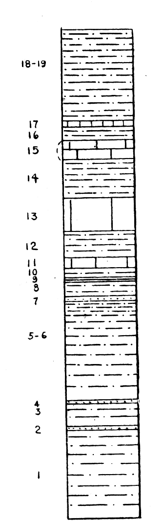
..................................................................... 
    Hemiaster, Lima, Pecten irregularis, 
    Enallaster texanus and many other fossils.
4. Chalky limestone ........................................................
    The bottom of this layer is about at the 
    level of the approach to the dam. 
3. Massive impure fragmented chalky limestone, 
    marly at the base..........................................................
1. Massive chalky limestone overlying the Walnut 
    shell conglomerate and seen in the channel below 
    the dam........................................................................
 
       Total.........................................................................

Walnut Conglomerate:
    Massive blue gray shell conglomerate composed 
    mainly of Gryphea marcoui shells..............................
7' 0"


10' 0"


43' 0"


5' 0"

117' 0"


5' 0"

 The Fredericksburg limestone can be studied to advantage on the steep slopes of the valley of the West Fork, just northeast of the Lake Worth dam, where its fossil sequence is excellently displayed. The following series of levels holds for any locality in Tarrant County within narrow limits, and may be used at Lake Worth, Mary's Creek north of Benbrook, Bear Creek southwest of Benbrook, Azle Road sections northwest of Fort Worth, and Stove Foundry Road [Vickery] sections along the Texas and Pacific track between Fort Worth and Benbrook.

DISTANCE OF FREDERICKSBURG FOSSIL HORIZONS AND ZONES OF ABUNDANCE BELOW THE TOP OF THE FREDERICKSBURG LIMESTONE, IN TARRANT COUNTY

Feet.
Fossils sparse..........................................
Corals: Parasmilia, Trochosmilia..............       
Diplopodia.............................................
Salenia (upper level)........................ 
Trichotropis shumardi....................... 
Exogyra plexa.............................. 
Lima (abundant)........................... 
Ostrea sp. aff. munsoni...................... 
Schloenbachia belknapi ...................... 
Hemiaster sp. (small) ....................... 
Salenia (lower level)........................ 
Protocardia filosa........................... 
Exogyra texana...................................
Natica pedernalis ...........................
0-16
23
24
26
27
28
28
28
40
36
55
57
40-57; 90-100
110

The Geology of Tarrant County    31

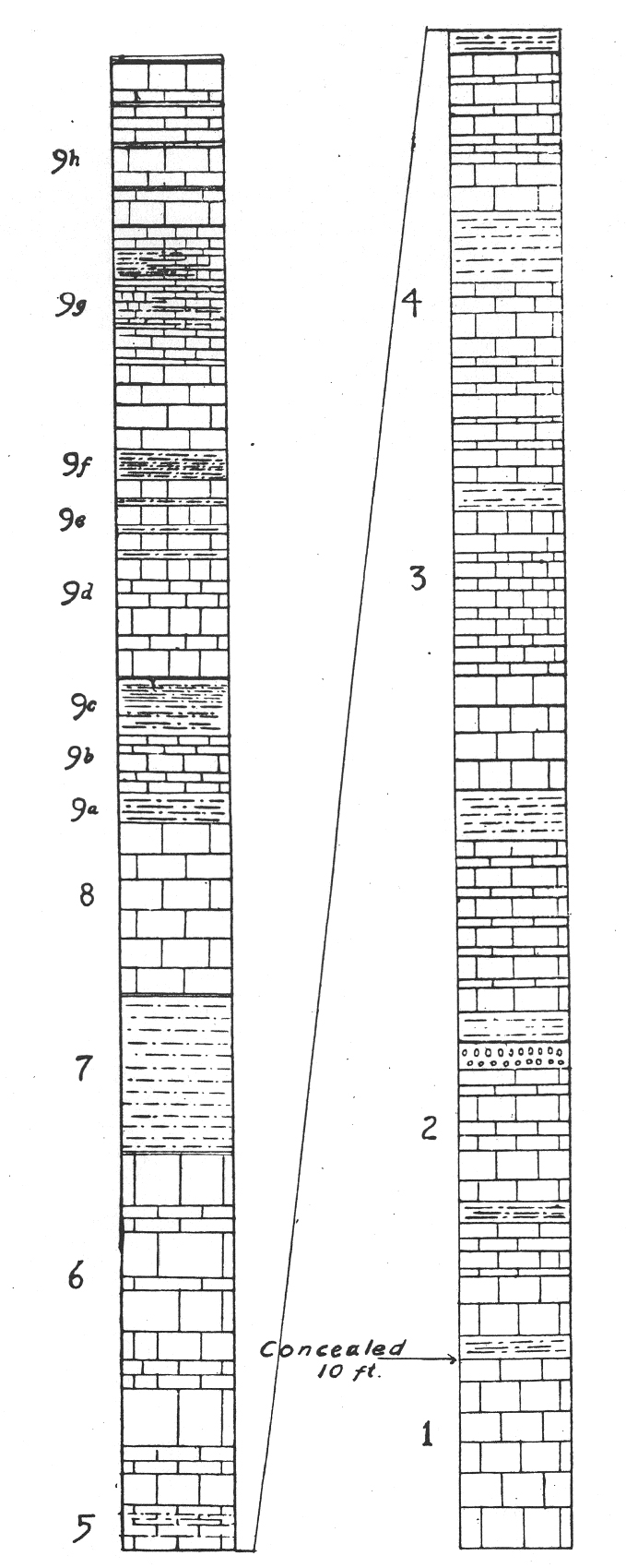
Fig. 1. Columnar section of the Fredericksburg limestone in the valley of the West Fork of the Trinity River near the Lake Worth Dam. The upper half of the section is seen in Plate 1. The numbers refer to corresponding strata described on pp. 29-32. Vertical scale, 1/8 inch=l foot.


32    University of Texas Bulletin

 The portion of the Fredericksburg Division lying between the limestone just described and the Paluxy sand below, consists of. alternating conglomerate and sand layers totaling about 100 feet in thickness. This series of strata constitutes the prominent escarpment seen below the Fredericksburg limestone on the Azle road, two miles east of Azle, on the Weatherford road near the county line, and elsewhere in the northwest corner of Tarrant County. The topmost impervious conglomerate protects the underlying unconsolidated sands from weathering, and thus gives to the whole escarpment a resistant appearance. In fact the cap conglomerate breaks off and strews the slopes of the hills with fossiliferous slabs and debris. This topmost layer sometimes weathers unevenly, and small hard caps remain, forming the Walnut peaks seen near Azle. The shell conglomerate outcrops around Lake Worth, where it is seen at the small exposure just below the dam and for several miles up the river. This basal Fredericksburg belongs to the Walnut formation but the upper contact will not be defined here.

SECTION OF THE LOWER PORTION OF THE FREDERICKSBURG DIVISION, ON AZLE ROAD, TWO MILES EAST OF AZLE, TARRANT COUNTY, TEXAS

  Thickness
   in feet.
Brown limy marl with Gryphea marcoui, Turritella, Exogyra texana, Enallaster, Natica............................... 
20'
Blue-black shell conglomerate, containing Gryphea marcoui (in great numbers), Trigonia, Pecten subalpina, Pecten sp., Exogyra texana and spp., Cyprimeria, Turritella, Enallaster texanus, Remondia (?), Lunatia sp....................... 


5'
Unconsolidated sand, slightly yellow stained, containing ferruginous fragments. No fossils noted........................ 
75'
Arenaceous reddish limestone and shell conglomerate, containing Gryphea marcoui, Turritella sp., Enallaster texanus, Exogyra texana  ............ 

25'
Paluxy sand.  

 The upper conglomerate of the Walnut, a mass of Gryphea marcoui shells, is seen in the east bank of Lake Worth at the Nine-mile bridge, just opposite the bathing beach. It should be especially noted that there is another conglomerate having the same sequence of lithology and of fossils, lying stratigraphically 20 feet above this level and easily confused with it.

The Geology of Tarrant County     33

FAUNA OF THE GOODLAND LIMESTONE

Hemiaster whitei Clark
Hemiaster sp.
Enallaster texanus (Roemer) 
Holectypus planatus Roemer 
Salenia mexicana Schlueter 
Diplopodia taffi Cragin 
Cyphosoma texana 
Goniopygus sp.
Engonoceras sp. 
Schloenbachia spp. 
Schloenbachia acutocarinata
   (Shumard) 
Turritella seriatim-granulosa
   (Roemer )
Turritella sp.
Cinulia tarrantensis Cragin
Trichotropis shumardi Cragin 
Cylindrites formosus Cragin 
Cerithium bosquense Shumard 
Tylostoma chihuahuense Boese 
Tylostoma tumidum? Shumard 
Lunatia pedernalis Roemer 
Nerinea sp.
Neritina sp. 
Rostellaria subfusiformis Conrad
Turbo sp.
Homomya sp.
Pinna sp. aff. comancheanus 
   (Cragin)
Protocardia texana (Conrad)
Protocardia filosa (Conrad) 
Isocardia sp.
Cyprimeria texana (Roemer) 
Pecten occidentalis? (Conrad) 
Pecten irregularis (Boese) 
Pecten subalpina Boese) 
Exogyra texana Roemer 
Exogyra plexa Cragin (Boese) 
Exogyra sp. aff. plexa Boese 
Gryphea marcoui Hill & Vaughan 
Pholadomya sancti-sabae Roemer 
Ostrea sp. aff. johannae Choffat 
Lima wacoensis Roemer 
Trigonia sp. 
Tapes sp. 
Corbula sp. 
Schloenbachia sp. aff. belknapi 
   (Marcou) 
crustacean claws 
Trochosmilia texana (Conrad) 
Parasmilia austinensis Roemer

FAUNA OF THE WALNUT FORMATION
Exogyra texana Roemer
Exogyra weatherfordensis Cragin
Enallaster texanus (Roemer)
Remondia ? sp.
Gryphea marcoui Hill & Vaughan
Salenia sp. aff. mexicana

Turritella sp.
Pecten irregularis (Boese)
Triginia sp.
Schloenbachia acutocarinata 
   (Shumard)
Holectypus sp. aff. planatus

WASHITA DIVISION

 The Washita Division of the Comanchean Cretaceous is very fully developed in Tarrant County, and includes the following formations beginning at the base: Kiamitia, Duck Creek, Fort Worth, Denton, Weno, Pawpaw, Mainstreet, Grayson, and Woodbine.1

KIAMITIA MARL

 Brief Diagnosis: The Kiamitia formation is a brownish yellow, slightly calcareous marl, with scattered limestone, shelly and flaggy bands and abundant deposits of oyster shells, mostly Gryphea navia. It is 27 feet thick at Fort Worth. It weathers out usually into a narrow hillside slope which lies above the glaring white Fredericksburg limestone and below the scarp produced by the basal Duck Creek limestone. The outcrops are

l The inclusion of the Woodbine in the Washita Division is tentative on the part of the authors.


34    University of Texas Bulletin

usually grassy and poorly exposed, and due to their situation are often contaminated by gravel deposits. The limits of the formation are sharply defined in Tarrant County.

 Description of Localities: This formation skirts the western edge of the Black Prairie at the foot of its escarpment and forms a narrow sloping strip often less than 50 feet wide. Due to its narrowness and to the close affinities of the formation with the Fredericksburg strata (page 27) it has not been separately mapped; but it may be projected on the map by cutting off a hair-line strip from the east border of the Fredericksburg Division as mapped. The formation decreases in thickness and in shelliness southward. At Shawnee Creek, Denison, it is over 60 feet thick and has prominent bands of hard shell conglomerate distributed through most of its thickness. In Tarrant County the shell bands have disappeared and the shells are present in smaller amounts in the loose limy layers and the interbedded marls. On the Noland's River, southeast of Blum, the formation is 19 feet thick and very similar to its outcrops in Tarrant County. The constant features, from the Red River to the Brazos, according to Hill, are a basal member which is calcareous and argillaceous and contains quantities of shell fragments ; the upper part of the formation is a series of calcareous laminated blue clays which turn brownish-black upon weathering, interstratified layers of indurated calcareous clay (e. g., stratum 15 below) and laminated sandstone flags (strata 2, 4, 7, 17). The flags are somewhat calcareous and the whole formation shows iron discoloration. South of the Brazos the formation is attenuated, and near Round Rock is stated to be an "earthy, blue, marly, rather hard limestone" at the base of the Georgetown limestone. (Hill).

 In Tarrant County there are two general types of Kiamitia exposure, the hillside and the upland type, of which the latter is very rare and exceptional. If the overlying Duck Creek limestone has been leveled or brought to a very gentle grade over a considerable area, the Kiamitia will form a gentle slope backward from the resistant underlying Fredericksburg rocks and will produce the upland type of exposure. This sort of outcrop is seen at the western edge of Duck Creek uplands, hence its

The Geology of Tarrant County    35

rarity. The best examples are along the Azle road near Lake Worth. On the prevailing hillside outcrops exposures are produced in stream cuttings but they are very inconsecutive. The exposures lying near the main drainage lines are usually partly overlain by terrace gravel deposits. However, the present day lateral drainage is rapidly cutting into the uplands and the headwaters of these valleys show uncontaminated Kiamitia exposures.

 Nearly a complete exposure, lacking the upper contact, is seen on the Azle road, about 6 miles northwest of Fort Worth and 2½ miles northeast of Lake Worth, at the point where the road sections the Kiamitia marl and passes down thru the Goodland escarpment.

SECTION OF KIAMITIA MARL, AZLE ROAD, SIX MILES NORTHWEST OF FORT WORTH

    Height from
bottom of 
section
Thick-
ness
    From To Ft. In.
18-19  
17
16
Brown marl. Gryphea navia ...............
Hard shelly limestone.........................
Very fossiliferous bluish marl 
   "E. plexa zone"..................................
20'
19' 9"

19'
25'
20'

19' 9"
5


3

9
15

14
Fractured limestone, double band
   with central marl layer......................
Bluish fossiliferous marl.....................

18'
16'

19'
18'

1
2
13

12
11
10
Hard coarse grained limestone,
   blue upon fracture............................
Blue marl...............................................
Hard Shelly limestone.........................
Blue marl..............................................   

14' 4"
14'
13' 6"
13'

16'
14' 4"
14'
13' 6"

1


8
4
6
6
9
8

7
5-6
Blue shaly marl....................................
Brownish marl, bluish before
   weathering.........................................
Brown sandy flag................................
Blue marl, more compressed at top...
12' 10"

12'
11' 10"
6' 6"
13'

12' 10" 

11' 10"


5
2

10
2
4
4
3
2
1
Light colored soft sandy flag............
Blue marl...............................................
Light colored soft sandy flag............
Brown laminated clayey marl,
blue upon fresh exposure...................
6' 4"
5'
4' 10"
6' 6"
6' 4"
5

'4' 10"

1


4
2
4
2

10
A Fredericksburg limestone...................
   (Upper 2 feet of Kiamitia
   concealed by soil overwash)

36    University of Texas Bulletin

These several members in the Azle section may be arranged in three groups that can be distinguished and described as below:

Pig. 2. Columnar section of the Kiamitia formation in cut on Azle road, eight miles northwest of Fort Worth. The numbers refer to corresponding strata described on pp. 35-7. Vertical scale, 1/8 inch = 1 foot.

 Basal portion (strata 1-6) : Approximately the lower half of the formation is a clay-marl which is bluish or bituminous on fresh exposure and extensively laminated; is brown on weathering, breaks into cuboidal chunks, indurates locally in thin layers, and at places is sandy. Hill notes the following features of this portion: It is a dark blue clay resting directly upon the smooth surface of the white Fredericksburg limestone; at a level of 5 feet above the base is a persistent band of gray indurated limy clay (2) ; at places it is variably arenaceous in the basal portion and some layers very near the base are sandy; near Aledo (Parker County) there is a basal layer of laminated, sandy, very calcareous and argillaceous material which contains

The Geology of Tarrant County    37

large quantities of shell fragments. This argillaceous portion at the Brazos is not more than 5 feet thick.

 The Fredericksburg-Kiamitia contact is lithologically the most contrasting and abrupt change in the series. It is seen to advantage at the Marine Creek crossing of the Azle Road. Here the blue, closely laminated, flaky Kiamitia marl lies directly upon the flat but irregular and lumpy surface of the limestone. In stream cuts the marl may be removed exposing the limestone. At localities nearer Fort Worth a finely fragmental shell deposit was noted just over this limestone; and at the Texas Pacific Railroad crossing of the Clear Fork is a six inch slightly shelly, blue marl stratum at the base of the Kiamitia. As noted later the fossils are mainly continuous across this contact.

 Middle portion (strata 7-17) : This limestone portion is topographically and paleontologically the most interesting part of the formation. It consists of six thin limestone layers or flaggy, sandy layers, alternating with blue and brown calcareous, laminated, and in part carbonaceous, clay. Three of these layers (7, 9, 17) are calcareous sandstone flag layers each 2 or 3 inches thick; of the other three layers 13 is a hard, coarse-grained limestone, 11 and 15 are soft marly-chalky limestones. All of the layers are fossiliferous, and the formation, in richness of fossils, is quite the reverse of the description of Taff. The fauna is, however, poor in ammonites and echinoids.

 Upper portion (strata 18-19) : This is a clay marl, brown, nom-laminated and sparsely shelly, without the extensive conglomerate sheets which are so prominent in the upper Kiamitia of the Red River section. Gryphea navia and G. corrugata were noted in this portion.

 Paleontology: Although the Kiamitia formation has been placed in the Washita division it has strong paleontological affinities with the Fredericksburg, as shown by the following table:


38    University of Texas Bulletin

Fossils of the Kiamitia marl, at Fort Worth, Texas. Formation or formations in which fossil is found, indicated by asterisk in column opposite fossil named.
Fredericks-
    burg
Kiamitia Duck
Creek
Washita
Gryphea navia Hall         *    
Avicula leveretti Cragin   *    
Schloenbachia sp. (belknapi?) *    
Ostrea sp.   *    
Exogyra texana Roemer * *    
Pecten irregularis Boese * *    
Exogyra plexa Cragin * *    
Schloenbachia acutocarinata Shumard * *    
Isocardia sp. * *    
Homomya sp. * *    
Trigonia sp. * *    
Pecten subalpina ? Boese * * * *
Protocardia texana (Conrad) * * * *
Cyprimeria sp. * * * *
Gryphea washitaensis Hill   * * *
Gryphea corrugata Say   * *  


Kiamitia Fauna
(Forms known to occur only in the Kiamitia)
 

Members of Azle
section preceding,
in which fossil is
found

Pinna sp.......................................................... 3
Gryphea navia Hall........................................ 1-19

The typical G. navia is very abundant in the middle third of the formation at Fort Worth, though it forms thick conglomerates in the upper portion on the Red River. It is a massive imbricated shell, usually with a twisted beak.

Schloenbachia acutocarinata, Exogyra plexa (plicate and non-plicate forms), and Pecten irregularis were not seen above the stratum 16. Exogyra plexa is limited to this layer.

"16" is a very fossiliferous layer. Below it the fossils decrease in number and in the lower third of the formation are rare. Schloenbachia acutocarinata and Exogyra texana were not observed in the basal Duck Creek limestone as at the Red River.

The Geology of Tarrant County    39

DUCK CREEK FORMATION.

The Duck Creek formation at Fort Worth is divisible into four lithological and paleontological members beginning at the top:

(1) Kingena member -- the Duck Creek Marl.
(2) Scaphites member -- the Duck Creek Limy Marl.
(3) Schloenbachia sp. (aff. trinodosa) member, -- the Duck Creek Marly Lime.
(4) Desmoceras member -- the Duck Creek Limestone.

DUCK CREEK MARL AND LIMY MARL

These groups in Tarrant County consist of a series of prevailingly light colored yellowish-gray marls containing thin seams of impure fragmental chalky limestone. The marl is recognizable in the landscape as a gently sloping shelf or terrace lying at the base of the escarpment produced by the overlying Fort Worth limestone and sloping to the outcrop of a limestone layer which lies at the base of the Marl (stratum 17). Below this layer, which in stream cuts forms the edge of the marl shelf, the slope is steep and is continuous with that the the Duck Creek limestone escarpment below. The top of the Duck Creek limestone is a persistent grayish, usually lichen-incrusted band, outcropping below the edge of the shelf in the face of the escarpment. The outcrop of these strata is generally narrow and lies along the rim of the main escarpment as seen near the Texas Christian University at Fort Worth, and therefore its soil value is almost negligible. At places, however, it weathers into a brownish-yellow hillside slope devoid of rock and is then indistinguishable from the Fort Worth upland except for a slight topographic break at their junction. The series is 34½ feet thick near Fort Worth. It is characterized by the following well defined sequence of fossils:

Pleurotomaria austinensis zone 
Upper Kingena zone 
Pecten wrightii zone
Upper Gastropod horizon ..... Globiconcha (?), Turritella, 
Diplopodia zone, Fusus, Cerithium
Lower (Main) Kingena zone 
Goniophorus sp. zone 
Crania sp. zone
Limonite fossil (Lower Gastropod) zone, 
Scaphites sp B (top) 
Gerontic Ammonite zone... Hamites spp.
Pinna sp.


* Desmoceras AKA EoPachydiscus
* Schloenbachia AKA Mortoniceras


[ pages: 1-23 ... 24-39 ... 40-59 ... 60-85 ... plates ... index ]