[ pages: 1-23 ... 24-39 ... 40-59 ... 60-85 ... plates ... index ]

40
University of Texas Bulletin

  Description of Localities: The Duck Creek Marl and Limy Marl are distinct from the overlying Fort Worth limestone and the underlying Duck Creek limestone, both lithologically and paleontologically, and have as much justification for ranking as a separate formation as either of them. If they are to be placed with either it should be with the Fort Worth limestone, since the faunal changes are very abrupt at the end of the Duck Creek limestone.

  The Fort Worth-Duck Creek contact as here described and mapped, following the most frequent usage in the literature, is totally arbitrary. It is debatable if it would not be much better to place this contact below the abundant Kingena zone and the horizon of Pecten bellula or lower, so as to partition the ammonites and echinoids more accurately. Such a contact would be as well warranted lithologically and topographically as the present one, and more consistent paleontologically; but since the formations are of only local application, no insistence is placed on this matter of contact. There is a clear and mappable topographic break above the stratum 24, so that the overlying Fort Worth limestone, even if thin, makes a continuous miniature escarpment in the landscape. The only other consistent topographic break is at stratum 17, which is resistant to erosion and caps the underlying Duck Creek escarpment; 17 forms conspicuous horseshoe bend outcrops in runs, while 24 fails to withstand erosion. In this group of strata the limestone beds are soft, chalky and fractured, and the marls are yellowish, water-bearing and very calcareous. Due to the thinness and softness of the limestone bands these degrade rapidly and so produce no conspicuous surface features. Only the Duck Creek stratum 21 is noticeably sandy and flaggy. The limestones and marls grade into each other, and locally there is slight lateral replacement.

  The Duck Creek marl is typically exposed in the run above the first turn of the street car track north of Texas Christian University, and in the cut of the military road nearby.

41
The Geology of Tarrant County

Fig. 3. Columnar section of the Duck Creek formation in cuts near Forest Park, Fort Worth. The numbers refer to corresponding strata described on pp. 42-4. Vertical scale, 1/8 inch = 1 foot.


42
University of Texas Bulletin

SECTION OF THE DUCK CREEK MARL, ON BOTH SIDES OF RUN SOUTHEAST OF FIRST TURN OF STREET CAR TRACK, ¼ MILE NORTH OF TEXAS CHRISTIAN UNIVERSITY AND 3½ MILES SOUTHWEST OF FORT WORTH.  Altitude of top of Duck Creek Marl 680 feet.

Thickness        Ft.   In.
Fort Worth Limestone:
3. Soft chalky limestone; Pecten bellula, Pleurotomaria austinensis 6"
2. Marl. Pecten bellula 6"

1.

Soft fragmental limestone. Pecten bellula

6"


Duck Creek Marl:
24. Soft marl with chalky limestone  fragments. Kingena (Upper) horizon in lower half. Pecten wrightii zone 3 6
23. Soft chalky limestone. Kingena  (Upper) horizon. P. bellula. Forms a slight terrace 4

22.

Marl. Upper gastropod horizon. Turritella, Cerithium, Fusus, Gyrodes (?) 2

8

21. Soft sandy limestone flag.  Diplopodia zone 3
20. Marl. Pecten bellula 3 2
19. Soft chalky limestone. Lower (Main) Kingena zone 1
18. Straw colored marl 5  
16-17. Laminated limestone, gray and  iron-stained, indurated locally,   rather unfossiliferous, making  'horseshoe' bends where the  streams cut through  it, and  everywhere forming the cap  of the Duck  Creek escarpment  or at least a break in the  topography.  (The section is continued in the  cut of the military road through  the Duck Creek escarpment, 1/4 mile north of the University). 4
16-17. Laminated gray indurated limestone,    capping the crest of the escarpment. Kingena may usually  be found just above it. 4
13-15.. Marl. Gryphea corrugata, Hemiaster elegans, Schloenbachia sp. I, Goniophorus sp. 3
12. Crumbling, marly limestone. Pinna sp. 1 2

11.

Limy straw-yellow marl. Limonite fossil horizon (Lower gastropod horizon):  Nerinea sp. near pellucida Cragin, Lunatia,  Cinulia, Cerithium, Turbo

1


43
The Geology of Tarrant County

Thickness    Ft.  In.
9-10. Crumbling chalky very marly limestone Crania sp. 1   Hamites spp. 2'
7-8. Straw colored marl 2'

6.

Chalky or bluish impure limestone.  Limestones and marls continue downward to the Hamites zone in the bed of the run.

2'

SECTION OF THE DUCK CREEK FORMATION IN THE RUN FROM SOUTHEAST CORNER OF FOREST PARK TO THE FRISCO SHOPS.  LOCALITY, 3 MILES SOUTHWEST OF FORT WORTH AND ½ MILE NORTH EAST OF TEXAS CHRISTIAN UNIVERSITY. Altitude of lower Kingena Zone at second turn of car track, 640 feet.

Thickness   Ft. In.
Schaphites member (Limy Marl)
17. Gray indurated Limestone 2
16. Calcareous marl 2
13-15. Two equal limy ledges with thin interbedded marl layers 3
12. Calcareous marl 2
7-11. Three thin limestone ledges and two thicker marl layers 5
6. Compacted, closely bedded, impure limestone

4


Schloenbachia sp. (trinodosa?) Member. (Marly Lime):    
5. Compact limestone Calcareous marl. 1 6
4. Compact limestone in four equal layers with interbedded thin marl. 4 6

3.

Compactly bedded, lumpy, in part "fucoidal"  limestone mixed with bluish marl.

7


Desmoceras member (Limestone):
2. Bluish very impure limestone, slightly marly at top, but becoming more compact toward base and usually weathering into smooth cliff faces. 12

1.


Harder limestone with iron nodular inclusions.  
Hamites zone.  
(The members 1-2 are well exposed along the drive-way in the park near the east entrance).

2

* Desmoceras AKA EoPachydiscus
* Schloenbachia AKA Mortoniceras


44
University of Texas Bulletin

 Paleontology: Of the fossil zones to be mentioned, the Diplopodia zone (21), the Turrilites zone (19), the Crania zone (10), the Hamites spp. zone (11) and the Pinna zone (6) will be less easily located by the fossils than the others; however, they are easily located by their levels. The other zones are conspicuous. The most dependable fossil, both in the field and in well borings, for locating the Duck Creek Marl is the Lower Kingena (19). The marl above this Kingena zone contains frequent Pecten bellula, which in the Fort Worth limestone is sparse. The portion of the marl below the Kingena zone is harder to diagnose; it contains considerable numbers of Gryphea corrugata and other indistinctive fossils. The most conspicuous associations or syndromes of fossil are the upper and lower gastropod horizons, each containing several genera. It may be mentioned that iron pseudomorphs range considerably in the Duck Creek marl. The fauna of the Duck Creek, marl is essentially a shallow water fauna and has been stated to represent a shallowing and oscillating ocean bottom. The frequent turning of some shells, as Gryphea washitaensis, convex side upward is stated to indicate a bottom disturbed by local currents, and there are evidences that some other shells were washed into their place of deposition.

FOSSIL ZONES AND HORIZONS

 Upper Kingena Zone: This zone containing many small rounded brachiopods at present referred to the genus Kingena lies in stratum 23 and the lower half of 24, about 7 feet above the main Kingena zone. It is thicker than the main Kingena zone, and the Kingenas, are much sparser than in the main zone. Between the two zones no Kingenas have been found in situ, though washed down individuals are abundant to below the indurated ledge 17.

 Upper Gastropod Zone: This zone, which contains among other genera Cerithium, Turritella, Gyrodes (?), and Pleurotomaria austinensis, occurs in stratum 22, where the gastropods are abundant, and in 23-24 where they are sparse. This zone is apparently the lowest range of Pleurotomaria austinensis Shumard, of which smooth individuals showing only the first four or five whorls are found. It is a zone of abundance of

45
The Geology of Tarrant County

 Turritella sp., which is also abundant in the lower Kingena zone. The Gyrodes (?) sp. has not yet been found elsewhere by us.

 Diplopodia Zone: There is a zone of abundance of Diplopodia in the arenaceous limy flag layer 21. These slabs also contain plates and fragments of Hemiaster and other echinoids, Pecten subalpina and Lima.

 Lower (Main) Kingena Zone: This abundant brachiopod zone, occupying stratum 19, is about a foot thick. The material above and below it does not contain brachiopods. This is a soft chunky, limestone layer which weathers into scattered irregular angular fragments with intervening projecting harder masses. A square meter of area at one locality contained 260 brachiopods of various sizes and shapes and of probably several species. This is one of the most persistent, easily located, and important horizons in the series and has been traced for miles in both directions from Fort Worth. Kingenas occur at the following levels, so far as known to us :

(1) Mainstreet limestone, an extensive horizon near middle. Some of the individuals are much larger than any found at lower levels and are intermingled with those of smaller size and of various shapes, probably referable to several species. This is the horizon most frequently mentioned in the literature.
(2)  Denton marl, top: on the Noland's River near Blum. These individuals were mostly of large size.
(3) Duck Creek marl: Upper Kingena zone. Tarrant County.
(4) Duck Creek marl: Lower (Main) Kingena zone, Tarrant County.
(5)  Duck Creek Limestone, base. In Grayson County these brachiopods of the smaller size occur within 10 feet of the top of the Kiamitia conglomerate in association with Exogyra plexa Cragin, Schloenbachia belknapi Marcou and in Tarrant County they were found at this level in association with Salenia sp., Plicatula sp. and fish teeth.

Turrilites sp.

A single individual of a vertically ribbed species was found in the lower Kingena zone (19). This is the only turrilite known to us below the base of the Pawpaw in the North Texas section. In the European and Mexican sections Turrilites is well represented in the Vraconien.


46
University of Texas Bulletin

Goniophorus sp.
This level is characterized by a very restricted zone of a few inches thickness, containing great numbers of a minute salenid, 1/8 inch in diameter, which has a star-shaped apical system and narrow linear sutures.

Crania sp.
A zone of Crania sp. 1 is contained in stratum 10; the species is distinctive but rare, having yet been found nowhere else in the series.

Hamites spp.
Several small species of Hamites and related genera, quite distinct from the species of large Hamites in the basal Duck Creek limestone, have not been found so far outside stratum 10. These individuals are rather rare.

Pinna sp. 1.
A zone of Pinna sp. with fine concentric and spined imbrications occurs in stratum 6. It is rare and distinctive, but ranges somewhat.

Lower Gastropod Horizon.

This is an aggregation of peculiar small iron stained mud casts and iron pseudomorphs, occurring in strata 9-11. It includes Lunatia, Cinulia, Cerithium, Turbo, Nerinea sp. near pellucida Cragin, Schloenbachia sp., Hamites sp., and Scaphites sp. (top). Most of these fossils are less than 1 cm. in diameter. They are fairly abundant. This limonite fauna occurs at the Red River.

Scaphites sp. B.
This small gerontic ammonite of which usually only the coiled end is preserved, practically characterizes the Duck Creek Limy Marl member. In its upper range it is associated with the iron stained fossils of the lower Gastropod horizon. (Strata 9-11).

47
The Geology of Tarrant County

The following additional species, which range into the Fort Worth limestone, will also be mentioned here:

Pecten bellula Cragin
This fine ribbed pecten begins near the main Kingena zone (19) and is frequent up to the base of the Fort Worth limestone and present to the top stratum (33) of this formation.

Pleurotomaria austinensis Shumard
This gastropod has not been found by us below the Lower Kingena zone (19) of the Duck Creek Marl; it ranges into the base of the Fort Worth limestone where a fine individual with the body volution and the ornamentation was found. The last two volutions and the markings are usually absent.

Hemiaster elegans Shumard
This echinoid ranges from stratum 12 of the Duck Creek marl to high in the Fort Worth limestone, where it has a zone of abundance in the upper part of the formation.

Holaster simplex Shumard - low individuals
The low flat bottomed Holasters range from the indurated ledge (17) of the Duck Creek Marly Lime to the base of the Fort Worth limestone and are abundant between the two Kingena layers. They are mud casts, rarely with a calcareous test, are usually iron stained and faintly tuberculated.

Holaster simplex Shumarda - tall individuals
These tall and top heavy Holasters range from stratum 20 of the Duck Creek marl to near the top of the Fort Worth lime stone, being more abundant in a zone near the top of their range.

Pecten wrighti Shumard This strongly ribbed pecten begins at stratum 22 of the Duck Creek marl and is abundant in 23-24. Thereafter it is sparse and disappears high in the Fort Worth limestone. More than one species may be involved in this range. A similar Pecten occurs in the basal Mainstreet limestone.

Schloenbachia sp. I.
This ammonite begins at the lower Kingena zone and ranges into the base of the Fort Worth limestone.


48
University of Texas Bulletin

Gryphea corrugata Say.

  This Kiamitia and Duck Creek Gryphea is conspicuous in all the Washita strata below the indurated ledge (17) of the Duck Creek Limy Marl, and is probably absent above that point.

DUCK CREEK MARLY LIME AND LIMESTONE

  Brief Diagnosis: The basal part of the Duck Creek formation is a series of compact soft impure limestone strata, thicker bedded than the Fort Worth limestone and with less interbedding. It produces in Tarrant county the steep escarpment at the west edge of the Fort Worth uplands, but almost never itself forms uplands. The series is bounded above by the Duck Creek Limy Marl and below by the Kiamitia marl, and in Tarrant County is 27 feet thick. This portion of the Duck Creek formation is characterized by a remarkable sequence of ammonite zones which locate with exactness the various levels in the formation. The sequence is divisible into four groups, in part overlapping: 1. above, Schloenbachia spp. of the rostrata type; 2. Schloenbachia spp. of the inflata type; 3. Desmoceras horizon; 4. Hamites spp. horizon, at the base of the formation.

  Fossils collected by Shumard in the Duck Creek limestone of Grayson county, near Preston on the Red River, were described in 1858 by Marcou, who referred the beds to the Gault. The formation was first named by Hill, who described its lithologic peculiarities, mentioned some of its striking fossils, and defined it so as to include the marly strata lying between the limestone proper and the overlying Fort Worth limestone. The Fort Worth limestone in the old sense as used by Taff and others included the whole Duck Creek formation and at times various other formations. 

  Descriptions of Localities: Good localities will often be found in stream beds cutting down through the Duck Creek escarpment at the west edge of the Fort Worth uplands. The narrow strip occupied by this member is usually rocky, grassy and marked at the top by isolated clumps of shrubs and trees.

49
The Geology of Tarrant County

  Terrace topography is often present; and in case the Fort Worth limestone scarp is recognized the underlying terrace is the Duck Creek (Kingena) marl; the next underlying scarp is that of the Duck Creek with the limestone at its base; and the terrace beneath is the Kiamitia clay which makes usually a gentle slope downward to the Goodland limestone outcrop.

  The Duck Creek limestone is prevailingly an escarpment forming rock; very rarely is a Duck Creek upland present, and then it is of limited area and forms a transitional slope to the underlying Goodland escarpment.  Such an upland is seen on the Azle road northeast of the upper lake. More often the limestone forms a divide, but in this case it is usually capped by the harder Fort Worth limestone, as on the Arlington Heights divide. Sections of the Duck Creek escarpment are well exposed in Forest Park.

  Several good localities lie near the Azle road about two miles northeast of the upper lake. Northeast of Moslah Temple on this road eight and one-half miles northwest of Fort Worth is an extensive exposure of the ammonite zones of the lower Duck Creek. This portion also forms the rim of an amphitheater like depression on the headwaters of Marine Creek, Azle road, nine miles northwest of Fort Worth. Three and a half miles southwest of the court-house the formation is well exposed in Forest Park, where complete sections may be seen along a line from the park entrance to the Frisco shops; stream cuts a half mile west of the University also afford good exposures of the basal Duck Creek. The uplands around Plover and Primrose are well exposed. Those southwest of Benbrook are poor. The Duck Creek limestone interbedded with marl forms steep rocky slopes of hard terraced material which for a few miles southwest of Fort Worth makes a conspicuous escarpment bordering the broad alluvial river bottom; this escarpment with the Fort Worth prairies above is seen with striking effect from Benbrook.


50
University of Texas Bulletin

SECTION OF DUCK CREEK LIMESTONE IN FOREST PARK NEAR EAST ENTRANCE, EAST SIDE OF DRIVEWAY.

(Cemented Upland Gravel and cross-bedded sand at top of section.)

     Thickness    Feet Inches
3. White limestone mixed with marl, containing Schloenbachia sp. H., Pecten subalpina, Lima, Plicatula, etc. 4'
2. White limestone and interbedded marl, containing Desmoceras sp. and Schloenbachia spp. aff. S. inflata. The Desmoceras is more abundant in the basal strata (B) 12'
1. Harder massive grayish limestone, containing Hamites spp., Plicatula sp., and Pecten subalpina.

This stratum is seen along the driveway south of the other locality.
2'

The Kiamitia formation is not clearly exposed at this locality.

  A similar section is to be seen in the first run west of the University, while in the run from the Frisco shops the whole Duck Creek formation above the middle of the Democeras horizon, and most of the Fort Worth limestone are exposed.

  Paleontology: The Duck Creek ammonite series is one of the paleontological landmarks of the Washita division. The Duck Creek limestone is nearly constant in thickness at least from Woodville, Oklahoma, to Georgetown, Texas, and probably farther. The contained ammonite sequence is very widely distributed, possibly world-wide.

  A portion of this zonal sequence follows, beginning at top:

Schloenbachia sp. H., aff. trinodosa Boese.
Schloenbachia spp. F-G, inflata group.
Desmoceras sp. B.  [Eopachydiscus]
Desmoceras sp. A.  [Eopachydiscus]
Schloenbachia sp. E. aff. elobiense Szajnocha
Schloenbachia belknapi Marcou.
Inoceramus comancheanus Cragin, I. munsoni Cragin.
Hamites spp. and other gerontic ammonites.
51
The Geology of Tarrant County

FOSSILS OF THE DUCK CREEK FORMATION.

Ostrea subovata (?) Shumard. 
Ostrea sp.
Gryphea corrugata Say. 
Gryphea washitaensis Hill 
Pecten texanus Roemer. 
Pecten subalpina Boese. 
Pecten bellua Gragin 
Pecten wrightii Shumard 
Pectin sp.
Pinna sp.
Lima wacoensis Roemer
Inoceramus comancheanus Cragin
Inoceramus munsoni Cragin
Trigonia sp.
Pholadomya sp. 
Gyrodes sp. (?) 
Turritella sp.
Pleurotomaria austinensis Shumard. 
Fusus sp. 
Cerithium sp. 
Crania sp.
  Nerinea sp.
Turbo sp.
Lunatia sp.
Schloenbachia spp.
Schloenbachia belknapi Marcou
Hamites fremonti (?) Marcou.
Hamites spp.
Scaphites sp.
Turrilites sp.
Desmoceras spp.
Kingena wacoensis (?) (Roemer).
Kingena spp.
Diplopodia sp.
Hemiaster whitei Clark
Hemiaster sp.
Holaster simplex Shumard.
Hemiaster elegans Shumard
Salenia sp.
Callianassa sp.
Fish teeth.

FORT WORTH FORMATION.

  Brief Diagnosis: The Fort Worth formation includes a series of limestone and marl layers, each less than one foot thick, alternating rather regularly with each other. The limestones are chalky and dead, white, or are indurated, bluish interiorly and stained superficially with yellow or brown iron smears. The strata underlie broad stretches of upland grazing and farming country composed of a black soil, and in stream beds weather into small cliff faces with shelf-like projecting limestone layers. The formation is thirty feet thick in Tarrant County. It contains numerous characteristic fossils, such as Pecten bellula, Holaster simplex, Hemiaster elegans, Exogyra americana, Schloenbachia sp. J, and may be identified by the following sequence of fossil zones beginning at top:

Enallaster sp.   [Heteraster]
Ostrea carinata Lamarck.   [Rastellum carinata]
Exogyra americana Marcou.   [Amphidonte walkeri] 
Hemiaster elegans Shumard.   [Macraster elegans]
Pecten bellula Cragin.   [Neithea bellulus]
Schloenbachia spp. of inflata type size of austinensis Lasswitz.
Holaster simplex Shumard. 
Schloenbachia sp. J.   [Mortoniceras]
Pleurotomaria austinensis Shumard.

  A nearly complete exposure of the Fort Worth limestone and the overlying Denton Marl is seen on the west bank of Sycamore Creek about 1½ miles above its mouth. The limestone is exposed at several isolated localities, particularly the cliff along the creek at the southwest corner of Glenwood Park, which gives the following section:


52
University of Texas Bulletin
    Feet Inches
33. Marl, limy at top............................................................... 3  
32. Soft impure limestone.  Enallaster sp. 2............................. 3 3
31. Chalky limestone .............................................................   10
30. Marl.  Nerinea sp..............................................................   8
29. Limestone in 4 equal layers with thin marl interbedding.... 2  
28. Loose crumbly limestone.................................................. 1  
27. Solid, hard, yellow stained limestone................................. 1 8
26. Marl................................................................................. 1 6
25. Limestone in 4 equal layers with slight marl interbedding, but the bedding somewhat irregular near base............................. 2  6
24. Compact coarse grained limestone, iron stained and locally sparingly flinty................................................................... 1  3
23. Limestone, concretionary and fucoidal at top, followed by compressed marl (2"), limestone (3") and compressed marl (2") 1 3
22. Coarse limestone, fucodial at base........................................ 1  
20-21. Coarse grained fucoidal limestone with marl at top............ 1 5
19. Lumpy fucoid layer.............................................................   2
19. Brown marl.........................................................................   1
17-18. Chalky limestone with very calcareous coarsely laminated marl at base 1 3
16. Chalky concretionary limestone........................................   8
15. Brownish marl...................................................................   8
14. Chalky concretionary limestone....................................... 5
13. Brownish marl...................................................................   5
12. Hard, fine-grained, compact, slightly shelly lime-stone, semi-crystalline and iron stained at base......................................... 7
11. Blackish marl, brown or weathering. Lima, Holaster, Schloenbachia sp. J    6
10. Irregular, chalky limestone, Schloenbachia sp J ...............   4
9. Closely laminated calcareous marl, slaty color, speckled; Holaster simplex, Pecten bellula, Hemiaster elegans.........   5
8. Limestone, slightly lumpy or irregularly bedded ................   7
7. Laminated marl.................................................................   3
6. Limestone, irregularly bedded.............................................   8
5. Laminated marl.................................................................   6
4. Limestone, irregularly bedded............................................. 1 10
Total 30 1

The basal layers are not exposed here. The whole Denton marl, showing its usual character, thickness and fossils, is exposed in several places between Belzise Terrace and Sycamore Creek.

53
The Geology of Tarrant County

Fig. 4. Columnar sections of the Fort Worth limestone. A. On Sycamore Creek, northwest corner of Glenwood Park, Fort Worth. The Denton marl immediately overlies stratum 33. B. Eastward facing exposure in a run ½ mile east of Texas Christian University and ½ mile south of Forest Park, Fort Worth.

The numbers refer to corresponding strata described on pp. 52-4. Vertical scale, 1/8 inch = 1 foot.


54
University of Texas Bulletin

  Description of Localities: This formation in the restricted sense adopted by Hill occupies a strip of variable width running through the middle of Tarrant County from north to south. The type localities, ¼ mile east of the Texas & Pacific Railway station, Fort Worth, and on the river bank just north of the Courthouse are now almost obliterated, the former by erosion, the latter by grading and overwash. There has been some variation in the nomenclature of this formation, but as eventually defined, it "consists of a group of impure white limestones, very slightly arenaceous, regularly banded in persistent layers averaging nearly a foot in thickness and alternating very regularly with similar layers of marly clay. The limestones and marls occur in strata 4 or 5 inches to 2 or more feet in thickness. The marly layers alternate with the hard limestones in bands ranging from thin laminae to bed's 6 inches or more thick." "Paleontologically the formation may be defined as the horizon of Ammonites leonensis and Epiaster elegans." With little variation, the following sections may be taken as typical for Tarrant County:

SECTION OF FORT WORTH LIMESTONE, EASTWARD FACING EXPOSURE IN RUN ½ MILE EAST OF TEXAS CHRISTIAN UNIVERSITY, 3 MILES SOUTHWEST OF FORT WORTH, TEXAS. Altitude, top of exposure, 685 feet.

     Feet Inches
25. Three thin limestone bands with 2 interbedded marl layers 2 2
24. Laminated marl, with a 3" limy band in center 1 6
22-23. Limestone in 4 equal layers interbedded with thin much compressed limy marl 2  
21. Marl

6
18-20. Limestone in 3 laminated equal layers interbedded with thin, much compressed limy marl 1 3
18. Marl   6
16-17. Limestone
Laminated marl
Limestone
6
2
6
15. Marl   8
14. Limestone   6
13. Marl 10
12. Limestone 8
8-11. Blue marly Limestone 1 6
4-7. Laminated marl 3
3. Limestone 5
The basal strata 1-2 are exposed in the bend of the north of this locality.
55
The Geology of Tarrant County

  The formation is thus composed of a series of alternating beds of soft chalky limestone and calcareous marl. It differs from the upper Duck Creek beds in that there is a regular alternation of lime and marl, no bed in general is more than 1 foot thick, and the limestone strata indurate, especially in eastward facing exposures and form projecting ledges, the softer marl having eroded away. The marl layers are compactly laminated and very limy and grade evenly into the limestone, so that the exact limits are undefined even though they appear definite due to the weathering of the marl and the shelf-like projection of the limestone. In addition the hard layers vary slightly in thickness even in the same cliff face due to their being composed of uneven flaky accretions of calcareous material cemented together by limy marl.

  The contact of the Fort Worth limestone and the Denton marl is well shown at a point ½ mile south of the Frisco track and. 4½ miles southwest of Fort Worth.

    Feet
Denton Marl:
3. Shell conglomerate of Gryphea washitaensis, containing Ostrea carinata. Pecten subalpina, etc. 1
2. Bluish clay with innumerable Gryphea washitaensis adults and larvel stages 16
1. Brown sandy marl with many sandstone flags 8
25


Fort Worth Formation: 

33.  Straw-colored calcareous marl with limy fragments. Enallaster sp. E. texanus, Nautilus texanus, Pecten subalpina, Schloenbachia sp. I, Holaster simplex, Holaster elegans, Lima sp. 3
32. Three limy strata with interbedded thin marl layers

2

The lower Fort Worth strata are excellently exposed along this run.
Essentially the same sequence is seen north of the Frisco track, 3 miles north of Denison and along the Red River in Cooke County and elsewhere.

The base of the Fort Worth limestone is well exposed at the following locality:


56
University of Texas Bulletin

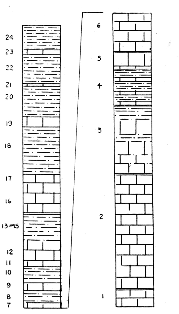
FORT WORTH AND DUCK CREEK FORMATIONS AT FIRST TURN OF CAR TRACK ¼ MILE NORTH OF THE UNIVERSITY AND 3½ MILES SOUTHWEST OF FORT WORTH, TEXAS. Elevation at base of Fort Worth limestone, 680 feet.

Fort Worth Formation: 


Feet

Inches

3.

Soft chalky limestone. Pecten bellula Cragin, Pleurotomaria austinensis Shumard


6

2.

Marl. Pecten bellula


6

1.

Limestone. Pecten bellula


6

Duck Creek Marl:


24.

Soft straw marl with chalky limestone fragments. Upper Kingena zone in lower half; Pecten wrightii

3

6

23.

Soft chalky limestone. Kingena, upper zone. Pecten bellula. Forms a slight terrace


4

22.

Marl. Gastropod zone: Globiconcha (?), Turritella, Cerithium, Fusus, Pleurotomaria

2

8

21.

Soft flaggy arenaceous limestone. Diplopodia zone.


3

20.

Marl.  Pecten bellula. 

3

2

19.

Soft, chalky limestone. Lower (Main) Kingena

1


18.

 Marl.

5


16-17. 

Laminated gray limestone, ironstained, locally indurated, rather unfossiliferous, making 'horseshoe' bends in streams.

4


  The rest of the Duck Creek formation is exposed in the run north of this locality.

  It is seen that the upper contact of the formation is unmistakable, and that the lower contact as here placed, leaves the Fort Worth limestone about 30 feet thick in Tarrant County.

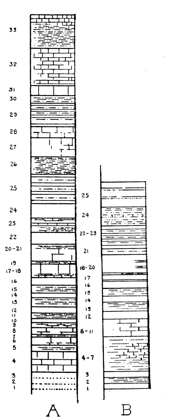
  Paleontology: The Fort Worth limestone contains certain diagnostic fossil zones, some of which are, beginning at the top:

Zone of Enallaster sp.  
In the uppermost stratum (33) are two or three species of Enallaster, of which one, an elongated low species occurring at this level at Denison, Fort Worth, Blum and elsewhere has not been seen at any other level.

57
The Geology of Tarrant County

Exogyra americana Marcou. This large characteristic oyster occurs in a restricted vertical zone (25-27) where it is abundant and easily recognized. It usually fails to weather out cleanly. It occurs at this level from the Red River to the Brazos; Dr. Boese has also found it near the top of the Duck Creek limestone in Grayson County.

Ostrea carinata (?) Lamarck. Fossils ordinarily referred to this species are much more widely distributed in the Texas Comanchean than has been suspected. This species is widely ranging and one of its zones of abundance is in the top of the Fort Worth limestone (28-29). The following occurrences are known to us:

(1) Buda limestone, Austin, Texas (Whitney).
(2)  Base of Mainstreet limestone, Fort Worth and Denton, Texas, below the Pachymya zone.
(3)  Pawpaw clay, Fort Worth, Texas, and elsewhere.
(4) Quarry limestone, Gainesville and Denton, Texas, abundant. 
(5)  Top of Weno limestone, Fort Worth, Texas.
(6) Denton marl, top. Conglomerate of Gryphea washitaensis and Ostrea carinata, widespread in north Texas (Hill's member i in 21 Ann. Rept. pt. 7, U. S. G. S., pp. 270-71 and elsewhere).
(7)  Fort Worth Limestone, top, zone below Exogyra americana, Gainesville, Fort Worth and Krum, Texas, and elsewhere.
(8)  Basal Fort Worth Limestone (1) Fort Worth, Texas.

  The positive identification of the individuals awaits comparison with European material. It may be mentioned that two cross-sections are prevalent; a triangular one and a semi-elliptical one.

Hemiaster elegans Shumard.
This echinoid begins in stratum 11 of the Duck Creek Marl and ranges upward to the top of the Fort Worth Limestone, with a zone of abundance in strata 22-24. There is considerable variation among individuals referred to this species, some being larger, broader and much flatter than others.

Schloenbachia sp. J.
This species ranges from the base of the Fort Worth Limestone to the top. It is most abundant in a broad zone near the base (1-5).

Holaster simplex Shumard.
Tall, top-heavy individuals referred to this species range from the indurated ledge (17) of the Duck Creek Limy Marl to the top of the Fort Worth, being most abundant near the middle of the limestone (22-24).


58
University of Texas Bulletin

Pecten wrighti Shumard.  [Neithea Wrighti]
This peculiar Pecten ranges from the Lower Kingena zone (19) of the Duck Creek Marl to the middle of the Fort Worth and is most abundant just below the base of the Fort Worth limestone.

Pecten bellula Cragin.   [Neithea bellula]
This characteristic fine-ribbed Pecten ranges from the lower Kingena zone (19) to the top of the Fort Worth, and is most abundant in the upper part of the marl.

FAUNA OF THE FORT WORTH LIMESTONE

Gryphea washitaensis Hill
Exogyra americana Marcou
Ostrea subovata? Shumard
Ostrea carinata ? Lamarck
Ostrea sp.
Plicatula spp.
Pecten subalpina (Boese)
Pecten wrighti (Shumard)
Pecten bellula (Cragin)
Pinna sp.
Trigonia sp.
Pachymya sp.
Pteria sp.
Remondia ? robbinsi (White)
Tapes sp.
Protocardia texana (Conrad)
Lima wacoensis Roemer
Lima sp.
Pholadomya shattucki Boese
Turritella marnochi White
Turritella seriatim-granulosa? Roemer
Pleurotomaria austinensis Shumard
Cinulia sp. aff. tarrantensis Cragin
Nautilus texanus Shumard
Schloenbachia spp.
Enallaster sp.
Enallaster texanus (Roemer)
Holaster simplex Shumard
Hemiaster elegans Shumard
Hemiaster sp. aff. whitei Clark
Epiaster aguilerae Boese
Ophioglypha texana Clark
Trochosmilia sp. 
Serpula sp. 
Lamna sp. [shark tooth]
fucoid masses

DENTON MARL

  Brief Diagnosis: The Denton marl is a very shelly blue-grayish marl formation, 25 feet thick in Tarrant County, lying between the Fort Worth limestone below and the Weno marl above. It is characterized by a great abundance of the oyster-like shells of Gryphea washitaensis, which especially near the top of the marl make a conglomerate containing also shells of Ostrea carinata.

  Lithology: The Denton shell marl is a shallow water deposit and has the texture and appearance of sediments deposited in modern seashore mud flats. It is excessively shelly, the shells being mainly adults and various young stages of the oyster, Gryphea washitaensis Hill.

59
The Geology of Tarrant County

 The mass of the material is a flaky, non-arenaceous, laminated bluish-gray calcareous marl, having considerable plasticity. The basal part of the formation is somewhat sandier, flaggy and less fossiliferous. The top of the marl is a bedded conglomerate of the Gryphea shells, which is usually slabby and breaks off into considerable sheets. The top of the formation is exposed ½ mile southeast of Our Lady of Victory Academy, Fort Worth, between the Missouri, Kansas and Texas Railway and the International and Great Northern Railway tracks; on Sycamore Creek, in the bluff below the Houston and Texas Central Railway bridge and at the waterfall just east of the International and Great Northern Railway track, both localities 4 miles southeast of Fort Worth; at points 1 and 2 miles southeast of Haslet and elsewhere. The top of the formation does not make a conspicuous topographic break as in Grayson County, where it forms a surface shelf at its outcrops. The base of the formation is exposed at a point ½ mile southeast of the Frisco track and 5 miles southwest of Fort Worth, and elsewhere.

SECTION OF DENTON MARL AT BLUFF 100 YARDS NORTH OF THE HOUSTON AND TEXAS CENTRAL RAILWAY BRIDGE ACROSS SYCAMORE CREEK, 4 MILES SOUTHEAST OF FORT WORTH, TEXAS.

Weno: Feet Inches
3.   Limestone................................................. 1  
2. Marl............................................................. 1 6
1. Limestone................................................. 1

Denton:
   
3. Unfossiliferous marl above, followed by Gryphea washitaensis Shell Conglomerate, two layers separated by a thin marly stratum and containing Ostrea carinata, Pecten subalpina, Trigonia, Plicatula, etc. 5  
2. Blue shelly marl with inconspicuous, scattered conglomerate layers. 21 6
1. Brown, sandy marl with a few thin, sandstone flags. Enallaster, Pecten, Plicatula, Lima.......... 1 6

[ pages: 1-23 ... 24-39 ... 40-59 ... 60-85 ... plates ... index ]