[ pages: 1-23 ... 24-39 ... 40-59 ... 60-85 ... plates ... index ]

60
University of Texas Bulletin

Fort Worth: Feet Inches
33. Very calcareous marl with Enallaster sp., Nautilus texanus, Hemiaster elegans, Pecten subalpina.. 3
22-32. Alternating limestone and marl layers......
(The lower portion of the Denton and the Fort Worth limestone are seen farther down Sycamore Creek).
20

Paleontology: The Denton marl has few restricted fossils and none that are absolutely distinctive, so far as now known. The fauna is marked by the abundance of Gryphea washitaensis and by the practical absence of ammonites and echinoids.

(a)   Association of Trigonia, Protocardia, Tapes. This loose association of pelecypods occurs in the lower, more arenaceous part of the Denton marl stratum. It is an aggregation which is easily recognized, though no one species is limited to this formation.

(b)  Association of Ostrea carinata and Gryphea washitaensis. Succeeding the uppermost strata containing Hemiaster elegans -- the top of the Fort Worth limestone -- are marly strata containing increasing numbers of Gryphea washitaensis and scattered individuals of Ostrea carinata. In Tarrant County this shelly marl culminates (stratum 3) in two thin slabby layers of shell conglomerate composed almost entirely of Grypheas but containing frequent Ostrea carinata, and Pecten subalpina, Plicatula sp. and other fossils.

 Gryphea washitaensis Hill ranges from the lower Duck Creek limestone to basal Mainstreet limestone. Its zone of greatest abundance is in the upper 10 feet of the Denton marl. Below this point, in both the Denton and the Fort Worth formations, it is scattered but frequent; while in the Weno and Pawpaw it becomes gradually sparser and in Tarrant County has not been found above the basal Mainstreet. Ostrea carinata occurs sparsely throughout the upper 10 feet of the Denton; it is locally abundant in the conglomerate slabs at the top of the Denton, though not so abundant as at the Red River. This is the main zone of this oyster always referred to in the literature; the other occurrences have been noted elsewhere (p. 57).

61
The Geology of Tarrant County

 The association of these two species as a persistent shell conglomerate makes a sheet of rock that extends throughout North Central Texas at this horizon, and is a paleontological landmark in the Washita division. As stated it is thicker and more prominent as a topographic factor at the Red River; at Fort Worth the conglomerate is only 1 foot thick and rarely withstands erosion, although it marks the soil along its outcrop with scattered, very easily recognizable shelly slabs. On Noland's River, near Blum, the Denton is much reduced and the conglomerate has entirely lost its slabby character, being only a loose, slightly calcareous and uncemented shell marl containing Gryphea washitaensis and a few Ostrea carinata. Farther south it is supposed to form a portion of the Georgetown limestone.

FOSSILS OF THE DENTON MARL
Leiocidaris hemigranosus (?) Shumard.
Ostrea carinata (?) Lamarck.
Gryphea washitaensis Hill.
Ostrea marcoui Boese.
Pecten subalpina Boese.
Pecten texanus Roemer.
Nautilus texanus Shumard.
Lima wacoensis Roemer.
Protocardia sp.
Trigonia sp.
Ostrea quadriplicata Shumard.
Plicatula sp.

WENO FORMATION

Brief Diagnosis: The Weno formation consists of a series of limestones and brown or yellow calcareous marls containing seams of limestone or ironstone, lying above the Gryphea conglomerate of the top of the Denton marl, and below the Pawpaw clays. It is 67 feet thick on Sycamore Creek near Fort Worth and nearly twice as thick at the Red River. In Tarrant County it is reduced in thickness but it is not in any way "consolidated" (with the adjoining formations) as has been claimed. It is abundantly fossiliferous. The top limit on the Red River is the Quarry Limestone group, but at Fort Worth this group is reduced and is recognizable only with difficulty; the contact in Tarrant County is placed at the junction of the white chalky Weno limestone below and brown sandy clay containing pyrite fossils, are described later (p. 67). The Denison and Gainesville sections of the Weno are essentially similar to each other. As we go south from the Red River the Weno thins, and becomes more calcareous and somewhat less fossiliferous. The nacreous and chalky fossils seen at the Red River and their ironstone casts and molds become rarer in southern Cooke County and are


62
University of Texas Bulletin

absent in this form at Fort Worth. The separate members of the Weno also seem to thin towards the south.

 As noted for the Pawpaw marls (p. 68), the ironstone seams of, the Red River section are replaced in Tarrant County, especially north of the Trinity, by great amounts of jasper-like pebbles. The Weno appears prevailingly as a yellow marl with chalky limestone layers.

 Description of Localities: On the east bank of the upper half of Sycamore Creek, which runs nearly in the strike, there is exposed for several miles a continuous section, from the Gervilliopsis ledge at the top of the lower third of the Weno, upwards to the base of the Mainstreet limestone. In addition, the pit at the Cobb Brick Yards, an exposure on Sycamore Creek 1/8 mile, below the brickyards and two exposures near the Houston & Texas Central Railway bridge across the Sycamore Creek show the basal third of the Weno and most of the Denton marl. These localities are rich in fossils; and the whole landscape reveals the very intimate relations between the topography and the underlying geological structure. The diagrammatic terrace features correspond accurately to the formations beneath them, and represent from bottom to top: (a) the top of the lower half of the Weno limestone, usually an inconspicuous terrace; (b) the top of the Weno limestone producing the first main terrace; (c) the second terrace, composed of the limestone cap over the Pawpaw clay; and (d) an erosion slope, often terrace-like, which represents the Mainstreet limestone capping the hill. In the portion of Sycamore Creek which runs nearly in the strike, the Gervilliopsis ledge forms the bed of the creek. South from Sycamore Creek the Weno-Pawpaw strip narrows and follows the edge of the reduced Mainstreet upland, close to the west border of the Cross Timbers, leaving the county west of Burleson. The outcrops are here covered with Woodbine and Mainstreet overwash. Northwards from upper Sycamore Creek the Weno-Pawpaw strip widens to about 3 miles and spreads over the uplands along the tributaries of Sycamore Creek. The cliffs of the two formations, with the Mainstreet upland above, border the river valley near Rivercrest for several miles east of Port Worth just as the Duck Creek and Goodland escarpments do in the western part of the county. North of the Trinity the strip widens, is gently sloping and, due to overwash, is mapable with difficulty.

63
The Geology of Tarrant County

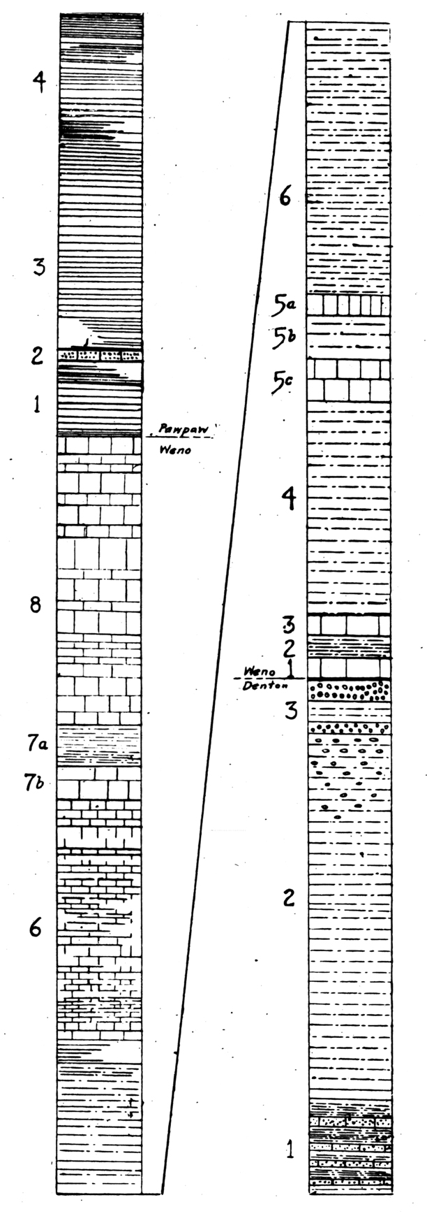
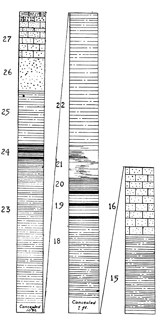
Fig. 5. Columnar section of the Denton, Weno and Pawpaw formations on Sycamore Creek, 3 miles southeast of Fort Worth. The numbers refer to corresponding strata described on pp. 58-69. Vertical scale, 1/8 inch = 1 foot.


64
University of Texas Bulletin

 Lower Weno: The Weno begins with two layers of chalky limestone separated by a marl layer and lying just above the Denton shell marl. From the base of these two layers to the base of a hard white limestone stratum containing clumps and scattered individuals of Gervilliopsis invaginata (White) is a layer of gray-blue or slate-colored, slightly laminated, jointed argillaceous marl, sometimes called a 'pipe clay.' It is rather fossiliferous and contains two fossils which especially distinguish it: a species of Turritella and Pecten sp. aff. georgetownensis Kniker, which differs from that species in having split ribs on only the right valve. This pipe clay is well exposed on the northeast bank of Sycamore Creek, 150 yards north of the Houston and Texas Central Railway bridge, where the upper Denton marl is also seen. The bluish Denton marl becomes less shelly near its top, and is abruptly followed by the two thin ledges, each about 8 inches thick and lying 1 foot apart. The pipeclay is capped by a thin ledge of fragmented chalky limestone, locally slabby and indurated. The lower Weno is 15 feet thick on Sycamore Creek.

 Middle Weno: The Gervilliopsis ledge, which is a persistent and reliable stratigraphic marker in the county, forms the bed of Sycamore Creek in its middle portion, where it runs almost in the strike, and elsewhere very consistently forms the resistant shelf of small, waterfalls, such as those at the crossing of the Houston & Texas Central and the International & Great Northern tracks and at the crossing of the International & Great Northern track over Sycamore Creek, both about 4 miles southeast of Fort Worth. The ledge is often indurated and fucoidal and is the base of a group of marly limestones which extend upwards for about 34 feet to the top of a chalky limestone layer which often makes a subsidiary terrace. At the brickyards 1¾ miles southeast of Gainesville, the Gervilliopsis ledge is a blue-gray loosely compacted marl 1 foot thick, containing great numbers of Gervilliopsis and other fossils and lying 39 feet below the top of the Quarry limestone group. In the branch of Duck Creek 1 mile north of the Union Station, Denison, the layer is also well developed.

65
The Geology of Tarrant County

 Upper Weno: The upper 18 feet lies between the subsidiary terrace in the Weno and the base of the Pawpaw marls. It consists of chalky white limestone and its upper limit is distinct, since the overlying brown marl washes away and leaves the top of the Weno limestone as a projecting shelf or terrace.

 Paleontology: The following is a brief summary of the Weno fossil sequence:

Pawpaw clay:     Pyrite fossil zone (p. 69).

Weno limestone and marl.
8. Nautilus sp., Homomya; Ostrea carinata (abundant). 
These species and others characterize the uppermost Weno Limestone. Certain of them occur in the basal Mainstreet limestone. The Ostrea carinata is conspicuous and abundant; its other occurrences have been noted (p. 57).
6-7. Nodosaria texana Conrad.
The Weno occurrence of this fossil protozoon is in a narrow zone about 19 feet below the top of the Weno. Nodosaria also occurs in the base of the Pawpaw in North Texas; in the Denison Beds at Cerro de Muleros; and in the Del Rio Clays, in association with Exogyra arietina Roemer in South Texas.
5. Gervilliopsis invaginata (White) 
The main zone of occurrence of this fossil is at the top of the 'pipeclay'. Its other occurrences have been noted.
1-4. Turritella sp., Pecten sp. near georgetownensis, Remondia acuminata Cragin.
These species are frequent in the basal part of the Weno pipeclay, where there exists a considerable fossil sequence that will not be discussed here.

Denton marl:   Gryphea washitaensis (abundant) and Ostrea carinata.

66
University of Texas Bulletin

FOSSILS OF THE WENO FORMATION IN TARRANT COUNTY (PARTIAL LIST)
  Weno Pawpaw Mainstreet Grayson Buda
Trochosmilia sp. 
Hemiaster calvini 
Hemiaster sp. 
Enallaster bravoensis 
Enallaster texanus ? 
Holaster sp. 
Cottaldia sp. 
Leiocidaris hemigranosa 
Nodosaria texana 
Pentagonaster sp. 
Trochosmilia sp. 
Turritella sp. 
Cinulia sp. 
Anchura sp. 
Turbo sp. 
Trochus sp. 
Schloenbachia sp. 
Schl. sp. like inflata 
Hamites sp. 
Engonoceras sp. 
Nautilus texanus 
Homomya sp. 
Pecten subalpina 
Pecten texanus 
Plicatula sp. 
Corbula sp. 
Tapes sp. 
Nucula sp. 
Astarte acuminata 
Protocardia sp. 
Ostrea quadriplicata 
Ostrea carinata 
Gryphea washitaensis 
Trigonia sp. 
Gervilliopsis invaginata
Ostrea sp. near marcoui
Lima sp. 
Lamna sp.
Oxyrhina sp.
*
*
*
*
*
*
*
*
*
*
*
*
*
*
*
*
*
*
*
*
*
*
*
*
*
*
*
*
*
*
*
*
*
*
*
*
*
*
*
*
*
*
*
*
*

*
*

*


*
*

*


*


*

*
*
*

*


*


*


*
*
*


*
*

*


*


*


*

*

*


*


*
67
The Geology of Tarrant County

PAWPAW FORMATION

 Brief Diagnosis: This formation on Sycamore Creek consists of 23 feet of brown arenaceous clay, lying below the hard, white Mainstreet limestone, and above the softer chalky limestone which forms the cap of the Weno formation. This brown clay contains sandy slabs in its basal half and carries a characteristic assortment of fossils. On account of its totally different color, hardness and composition, it should be easily recognized and separated from the adjoining formation in well drilling. Due to its increment in thickness northwards it is about 27' thick at the Denton-Tarrant County Line, while at the Tarrant-Johnson County line it is about 12 feet thick. The prevailing texture is sandy, the soil is acidic, the vegetation sparse; the slopes are variable, sometimes gentle but usually steep, making a narrow outcrop and good exposures. There is a sudden and marked increase in the amount of ironstone fragments in the Pawpaw northwards from the Trinity. The prevailing aspect of the formation, aside from this red material, is brown sandy-flaggy. The Pawpaw contains characteristic and unmistakable fossils. At the Pawpaw pit of the Cobb brickyards, Fort Worth, the total section is exposed, and shows a resistant, firm ironstained brown clay with ironstone, bituminous arenaceous and limy seams. 

 Description of Localities: There are numerous localities in Tarrant County, lying above the terrace formed by the top of the Weno limestone and weathering into a steep barren slope filled with sandy flags and limestone fragments. Such slopes in stream cuttings often recede considerably from the face of the Weno terrace and form extensive amphitheatre-like basins whose sides are continuous exposures of the whole Pawpaw and whose floors along the streamlets contain fine concentrations of the small fossils which occur near the base of the clay. Such localities occur along the middle and upper portions of Sycamore creek especially near the International and Great Northern railway bridge and thence northwards to the river; along the Trinity valley southeast of Riverside; at several localities southeast of Haslet; near Watauga; and near the Cleburne road


68
University of Texas Bulletin

south of Fort Worth. The localities are just underneath the western border of the Mainstreet limestone and naturally are contaminated with rock and fossils from that formation.

SECTION OF PAWPAW CLAYS ON SYCAMORE CREEK NEAR THE HOUSTON AND TEXAS CENTRAL RAILWAY, 4 MILES SOUTHEAST OF FORT WORTH, TEXAS:

   Feet  Inches
4. Brown slabby argillaceous thin limestone layers with considerable interbedded marl and scattered jasper pebbles. Nautilus sp., Hemiaster sp., Pecten subalpina; Plicatula sp. 13
3. Brown clay with scattered flags.  Turrilites sp. 6
2. Sandy flagstone, fragile, containing Metopaster sp. 4
1. Brown clay with pyrite and other fossils. 3 8
 

23

SECTION EAST OF KELLER ROAD, 1 MILE SOUTH OF HASLET, TEXAS:

  (Mainstreet limestone forms thin cap of hills around amphitheater.)    Feet Inches
3-4. Brown clay with flaggy and slabby dimension layers and great quantities of ironstone pebbles. Few fossils.................... 22 8
2. Flaggy layer 4
1. Brown clay with pyrite fossils................. 4
  27

 From these sections the increment in thickness towards the Red River is visible within Tarrant County.

PALEONTOLOGY
3-4. Nautilus sp. and Hemiaster sp.
  The upper portion of the formation, especially the upper 5 feet contains a small species of Nautilus and a rotund bulky species of Hemiaster. The middle part of the formation contains Nautilus sp. near texanus, Pecten subalpina, Plicatula, etc.
69
The Geology of Tarrant County
2.   Metopaster sp.
A thin flaggy stratum about 4 feet above the base of the Pawpaw contains the starfish Metopaster sp., which so far has not been found elsewhere and may prove to be narrowly limited. The zone also contains other species of starfish.
1. 'Pyrite Fossil Zone'.
Approximately the lower 8 feet of the clay contains an assortment of iron pseudomorphs and other fossils which is distinctive and includes the following:

Turrilites sp. 
Schloenbachia sp. 
Scaphites sp. A. 
Hamites sp. 
Area sp. 
Engonoceras sp. 
Cinulia sp. [gastropod]
Enallaster sp.
Salenia sp.
Fish teeth and vertebrae.
Baculites sp.
Flickia sp.
Acanthoceras sp.
Mortoniceras spp.

 The zone is present at this level at all localities in Tarrant County. The Turrilites are distinctive, and none has been found by us below the Pawpaw except a solitary vertically ribbed species in the Main Kingena zone of the Duck Creek marl.
 For brevity we call this a pyrite fauna; some fossils are pyrite, some hematite and some limonite.

MAINSTREET FORMATION

  Brief Diagnosis: The Mainstreet limestone, the second most important upland forming rock in Tarrant County, underlies a belt of irregular width just west of the Eastern (Woodbine) Cross Timbers. Its outcrop is a dissected dip plain modified by erosional slope towards the stream valleys, and is essentially similar to the Fort Worth limestone prairie. The Grayson marl lies between it and the Woodbine Cross Timbers, and the brown Pawpaw clays underlie it. It is thus sharply limited both above and below and should be recognizable in well drilling. It is characterized by the sequence of fossils listed later. The Mainstreet limestone totals about 50 feet in thickness at Fort Worth.

 Lithology: The formation with little variations from top to bottom, is composed of regularly alternating strata of straw-colored marl and chalky, or hard fairly pure limestone. The bands do not usually exceed one foot in thickness and the


70
University of Texas Bulletin

formation has a deceptive similarity to the Fort Worth limestone.

  Description of Localities: This limestone forms conspicuous and extensive uplands. In general appearance these are much like those formed by the Fort Worth limestone. The uplands of the Mainstreet limestone extend from one end of the county to the other in a north south line passing east of Fort Worth. The extensive and gently rolling area between the Burleson and the Cleburne roads in the southern part of the county is underlain by this formation. Good exposures may be seen along Sycamore creek, from the region of the Glen Garden country club southeast; in the stream cuts between Seminary bill and Crowley; along the road from the Burleson pike to Crowley, where almost the entire thickness is passed through; near Keller, and other parts of the county. The lowest strata are well exposed in Sycamore Creek about one half mile north of Crowley. This part of the formation is highly fossiliferous, Holectypus limitis (?) and Pachymya sp. aff. austinensis being especially abundant. Turrilites brazoensis which ranges throughout the formation occurs here, but is more abundant higher up, as in the exposures along Deer Creek between Burleson and Crowley.

  The upper portions of the formation are well exposed at various places along the Keller road, especially just south of Keller.

  The upper portion may be seen also at the crossing of the Mansfield road and the Cleburne-Fort Worth interurban railway.

  Paleontology: The Mainstreet limestone can be identified and its levels distinguished by means of the fossil sequence, which in part is as follows:

 Leiocidaris sp. Rarely spines of this echinoid are seen high in the Mainstreet formation. Cyphosoma and other echinoids are associated with it. It lies nearly at the top under the level of Exogyra sp. 2 which occurs in the basal chalky marl of the Grayson formation.

  Turrilites brazoensis Shumard. The upper ten feet or so of the Mainstreet formation is rather barren; below this, Turrilites appears and ranges downward as low as the Holectypus zone, which is about eight feet above the base of the formation. The greatest abundance of Turrilites is about eighteen feet below the top of the formation. It may be seen in greatest abundance at the Deer Creek crossing of the Cleburne interurban.

71
The Geology of Tarrant County

  Kingena wacoensis? Roemer. This distinctive large brachiopod is not found outside of the Mainstreet limestone except possibly in the Denton marl of the southern section. A zone of great abundance and almost the highest occurrence is about 20 feet above the base of the formation; the lower limit is the base of the formation itself.

  Schloenbachia sp. O, like inflata. Throughout the Mainstreet.

  Exogyra arietina Roemer. This tall spired Exogyra begins about the middle of the Mainstreet limestone and ranges upward into the. basal Grayson.

  Ostrea quadriplicata Shumard. This characteristic fossil of the Denton, Weno and Pawpaw formations has not been seen above the basal Mainstreet, where it is rare.

  Holectypus limitis (?) Boese. Large sized Holectypus are abundant in a zone about eight feet above the base of the Mainstreet formation.

 Ostrea carinata Lamarck. One of the numerous but distinctive occurrences of this striking oyster is a stratum in the basal Mainstreet limestone. This and the following zone may be seen along the Cleburne road.

  Pachymya sp. aff. austinensis Shumard. A narrow zone of this fossil characterizes the base of the Mainstreet, where numerous well preserved individuals occur. We have seen it elsewhere only in the middle of the Weno limestone.

FOSSILS OF THE MAINSTREET FORMATION (PARTIAL LIST)

Ostrea sp., aff. marcoui Boese
Ostrea carinata (?) Lamarck.
Ostrea quadriplicata Shumard
Lopha sp.
Ostrea subovata Shumard.
Exogyra arietina Roemer.
Exogyra sp.
Gryphea sp.
Pecten texanus Roemer
Pecten subalpina Boese
Pecten wrightii Shumard
Pecten roemeri Hill
Pecten spp.
Spondylus cragini Whitney.
Lima wacoensis Roemer.
Protocardia vaughani Shattuck.
Pholadomya shattucki Boese.
Ptychomya ragsdalei Cragin
Pachymya sp. aff. austinensis  Shumard Homomya sp.
Barbatia Simondsi Whitney
Trigonia sp.
Schloenbachia sp. aff. inflata.
Turrilites brazoensis Shumard.
Turrilites sp.
Nautilus texanus Shumard.
Nautilus hilli Shattuck.
Kingena wacoensis (?) Roemer.
Cyphosoma volanum Cragin.
Holectypus limitis (?) Boese.
Enallaster bravoensis Boese.
Enallaster sp.
Hemiaster sp.
Leiocidaris sp. aff. hemigranosus Shumard.

72
University of Texas Bulletin

GRAYSON MARL

  Brief Diagnosis: The Grayson marl in Tarrant county is exposed either as a steep narrow marl band lying against the western margin of the Woodbine Cross Timbers or as a gentle slope connecting the Woodbine sands with the Mainstreet upland. In either case it is at nearly all places covered with overwash and vegetation. Exposures are more rare than in any other Comanchean formation. The marl is yellowish-brown and locally contains pyrite seams and fossils, gypsum, and interspersed thin limestone bands. The formation is about 50 feet thick at its outcrops near Fort Worth.

  Descriptions of Localities: The best and most accessible localities are a cliff one mile east, and a small divide about two miles southeast of Burleson, just outside of Tarrant county. The slopes of the Woodbine hills just west and northwest of Burleson also bear isolated exposures of the Grayson marl. The Texas and Pacific railway cut one-fourth mile east of Handley exposes the middle portion of the formation, as do small stream cuts one mile west of Handley.

SECTION OF THE GRAYSON MARL, 2 MILES SOUTHEAST OF BURLESON, JOHNSON COUNTY.

     Feet
3.   Yellowish calcareous marl, sparsely fossiliferous 12
2. Shelly limestone band 1
1. Yellowish calcareous marl, with gypsum, pyrite and limonite. Gryphea mucronata, Exogyra sp., Pecten subalpina, Hemiaster calvini, Enallaster sp., Turrilites sp., Lima sp., Engonoceras sp., abundant small pyrite fossils..................
(Top and base of Grayson marl not exposed here).


15
  
  No locality clearly showing the Grayson-Woodbine contact has yet come to light in Tarrant county. This contact has been claimed by Taff to be unconformable at the locality on the Red River in Cooke county, which is now much obscured by Woodbine overwash. The Grayson marl locality just east of Burleson is rich in Pecten subalpina, Lima, sp., Gryphea mucronata, and contains Cyphosoma volanum, Hemiaster calvini, Enallaster bravoensis and Engonoceras.
73
The Geology of Tarrant County

  None of these exposures shows the entire thickness of the Grayson marl. In the cliff east of Burleson about 50 feet is exposed, reaching not quite to the Grayson-Woodbine contact; while between, the bottom of the exposure and the Mainstreet limestone near Village Creek there is at least 20 more feet of basal Grayson. Part of these basal strata are seen at the locality 2 miles southeast of Burleson. At Handley likewise, the Grayson is probably about 70 feet thick, and here as usually the upper part is mantled by Woodbine overwash, a sandy, red, timbered soil whose, presence everywhere makes the Grayson appear abnormally thin.

  Perhaps the completest exposure known is in a tall bluff 3 miles ESE. of the bridge of the Fort Worth-Denton road over Denton Creek, east of Roanoke, Texas. This shows an apparently conformable contact of the Grayson with the overlying Woodbine, and also the contact with the underlying Mainstreet limestone. The Grayson here is 75.2 feet thick.

GRAYSON MARL NEAR ROANOKE, TEXAS

WOODBINE:
Red ledge, forming crown of hill.
Feet 
GRAYSON:
Soft gray marl containing eleven limestone ledges, each 3 to 12 inches thick, the uppermost lying in contact and conformable with the base of the Woodbine.
  Lima sp., Protocardia sp., (same as the Weno sp.), Cidarid spines (very large), zone of Hemiaster calvini and Enallaster bravoensis (10 feet below top), Schloenbachia sp., Cyprimeria sp., Gryphea mucronata (scarce), Pecten texanus (abundant), Plicatula (abundant), Scaphites ? sp..............
37.8
Yell owish limonite stained marl. Rich in Gryphea mucronata. Turrilites (small sp.), no other ammonites seen; no echinoids seen. Pecten texanus, less abundant than above............ 15.2
Soft gray marl. Fossils scarce, mostly Engonoceras sp., Gryphea mucronata and flattened Exogyra arietina. A number of red ironstone seams weathering out black...................... 22.2
 
MAINSTREET LIMESTONE:
Top: Kingena sp. very abundant.
This locality is noticeably more calcareous than those farther west.

74
University of Texas Bulletin

SEQUENCE OF GRAYSON FOSSILS

The following paleontological sequence is taken from the Burleson, Roanoke and Denison localities:   

WOODBINE:
Ostrea carica and spp. Seen at Burleson and elsewhere immediately overlying the Grayson. 
GRAYSON: 
a.    Zone of abundance of Hemiaster calvini and Enallaster bravoensis about 10 feet below top. Associated fossils: Pecten subalpina, Pecten texanus, Lima sp., Protocardia sp., Cyprimeria sp
b. Zone of Acanthoceras sp. and Tissotia ? sp. 20-30 feet below top.  Associated fossils: Cyphosoma volanum, Pachymya sp., Protocardia texana, Turrilites (small sp., ranges down to Pawpaw).
c. Zone of abundance of Gryphea mucronata. Associated fossils:  Pecten texanus, Pecten sp. aff. subalpina, Inoceramus sp. 45 feet below top of Grayson.
d. Exogyra sp. 1. Associated with Pectens, Gryphea and Lima. 45-55 feet below top.
e. Engonoceras sp. About 65 feet below top.
f. Association of Nautilus, Enallaster bravoensis, Enallaster sp. near texanus, Holectypus limitis, Gryphea mucronata, a salenid, Pecten, Lima and other pelecypods.
g. Exogyra arietina and sp. This zone lies just beneath the preceding, at the base of the Grayson. Turrilites sp. is abundant in both layers. The zone is underlain by Mainstreet limestone containing abundant Kingena.

FOSSILS OF THE GRAYSON MARL
Gryphea sp. like corrugata Say.
Gryphea mucronata Gabb.
Exogyra spp. 1-3.
Exogyra arietina Roemer.
Exogyra sp. like texana Roemer.
Pecten subalpina (Boese).
Turrilites spp. 1-2.
Arca sp.
Lima sp.
Cyphosoma volanum Cragin.
Ostrea sp.
Anomia sp.
Plicatula spp.
Protocardia sp.
Tapes sp.
Pholadomya shattucki Boese.
Trigonia sp.
Cerithium sp.
Cinulia pelletti Whitney.
Turritella sp.
Hemiaster calvini Clark.
Enallaster bravoensis Boese.
75
The Geology of Tarrant County

WOODBINE FORMATION

  Brief Diagnosis: The Woodbine formation is a series of sandy iron stained, argillaceous clay strata and ironstone; which weathers into low rolling hills with open glades and flats of bottom land. The outcrop, which covers roughly the eastern third of Tarrant county, is heavily timbered with black jack oak and post oak, and is known as the Eastern (Upper) Cross Timbers.

  The soil is sandy, red, and acidic, and is suitable for special purposes as fruit growing. The outcrop forms the catchment area for the Woodbine artesian reservoir whose water bearing sands dip eastward, underlying at an increasing depth a large area in north central Texas.

  The Woodbine has been divided into two divisions, the lower (Dexter) sands and the upper (Lewisville) beds. The latter are locally fossiliferous. The series has been considered about 300 feet thick between Handley and Arlington.

  R. T. Hill 1 gives the following excellent description of the Woodbine formation: ''The rocks of the Woodbine formation are largely made up of ferruginous, argillaceous sands, characterized by intense brownish discoloration in places, which are accompanied by bituminous laminated clays. These sands, like those of the Trinity division, are unconsolidated in places, but differ from them by containing a greater proportion of iron and other mineral salts, which materially influence the character of the waters derived from them. The sand, which in the unoxidized substructure are usually white and friable contain particles of iron occurring with glauconite and pyrite. These minerals oxidize toward the superficies, and their solutions consolidate the more porous beds of sand into dark brown siliceous iron ore, occurring in immense quantities in certain localities. Other beds of sand break down into deep loose soils. These support a vigorous timber growth."

  Description of Localities: The Woodbine sands are poorly exposed in Tarrant county due to the small, inconsecutive sections, the softness of the strata and the consequent very general overwash, and the extensive timbering. The best series of exposures is along the road east of Birdville, and the Rock Island railway cuts east of Tarrant station. The basal contact of the Woodbine was not anywhere seen with clearness, although localities near Burleson and Handley have the basal part poorly exposed. The upper contact with the Eagle Ford shales is seen in Taff's

1 Hill, 21st Ann. Rept. U. S. G. S., part 7, p. 294.


76
University of Texas Bulletin

locality on Bear Creek, ¼ of a mile west of the Tarrant-Dallas county line and 2½ miles northeast of Tarrant. A few basal strata are visible in cuts of the Fort Worth-Dallas interurban, 2 miles east of Handley.

  An excellent section of part of the Woodbine formation near the base is seen at the pit of the Acme brick yards, Denton, Texas. This section is forty-two feet deep, and is strongly acidic in all of its material. The alternation of argillaceous bands with pure sandstone beds is striking. There is a perceptible stratification, apparently with conformable members, except at the top. Here there is either the end of a lenticular mass or the beds represent the foreset laminae of strong cross bedding. The former is the more likely, especially since about a mile distant and in the plane of the cut, a similar group of beds is shown whose dip is strongly against that of the beds, suggesting the other edge of the lenticular mass.

SECTION IN THE PIT OF THE ACME BRICK YARDS, DENTON, TEXAS:
Feet
5.  Lenticular mass, four members, overlain by a red sandy clay 15
4. Light colored limonitic argillaceous member 7
3. Red Sandstone  5
2.  Light colored limonitic argillaceous member 1
1. Grayish sandy argillaceous member, 
containing several bands of almost black sandstone
14
42

A 25 foot boring at this point penetrated the Grayson marl.

SECTION OF WOODBINE EAST OF TARRANT STATION

(The following section is seen south of the railroad below the first bridge west of the county line.)
Feet Inches
27.  Sandstone ledge, locally a shell conglomerate, containing Barbatia micronema Meek, Ostrea soleniscus Meek, Ostrea carica Cragin, Ostrea sp., Exogyra sp., and other Lewisville fossils. The upper portion is indurated, laminated and especially fossiliferous. Exposed in three cuts nearest
77
The Geology of Tarrant County
   Feet Inches
  the Tarrant-Dallas County line. This is the top of the Woodbine and is overlain by Eagleford shale. Between the two localities it has locally a dip of 2½° East, but this reduces at most places to about ½° East. 7
26.   Light yellowish sand with limonitic stain, usually unconsolidated and containing Ostrea sp. (with large attachment scar). 5  
25. Arenaceous yellow-brown shales containing Ostrea sp. 8  
24. Three ironstone bands interbedded with bluish sandy shale. 2  
23. Thin bedded closely laminated shale with dimension layers of iron stained red shale, and containing gypsum, limonite and oyster shells (O. carica).
The lower 10 feet is especially fossiliferous.
(The section in the cuts west of this locality exposes all of the foregoing members, and in addition in a deep run about a mile east of Tarrant, the following section is exposed.)
22  
22. Bluish red shale with limonite stain and abundant gypsum. Ostrea carica is rare in the top 20  
21. Loosely laminated thin bedded brown shale, weathering to a rough faced cliff 5  
20. Compact laminated brown shale forming a smooth cliff face. 2  
19. Three thin red ironstone layers with interbedded compact blue clay. 4  
18. Blue limonitic shale.
(There is a break in the section at this point. A cut of the Rock Island Railway 1/2 mile east of Tarrant exposes the following section.)
12  
16. Thin bedded red sandstone, no fossils seen. Minor faulting present. Gypsum present. Dip is 2 degrees east in the west end of the cut, and straightens out to 1 degree in the east end. 10  
15. Blue shales containing gypsum and lignite seams. No fossils 12  
  
  It is doubtful if many of these members are continuous over great areas. There is a break in the section near Tarrant station. There is a middle sandstone member of the Woodbine formation which consists of massive red sandstone, and which seems extensive. Its structure is complicated by lenticular

78
University of Texas Bulletin

masses and by sharp reversals of dip. About 2 miles west of Tarrant station at the crossing of the Arlington-Grapevine road and the Rock Island railway, is a massive sandstone ledge. A cut of the railway 2 miles west exposes a similar sandstone ledge. Cuts along the first parallel road north of the Rock Island railway, from Birdville to the county line and a few cuts south of the railway expose the lower half of the Woodbine formation. There is locally at least a basal sandstone which forms the resistant cap of certain "Brushy Knobs." For example, on the knob 2 miles northwest of Burleson, the basal strata of the Woodbine are seen to be in part a sandy shale and in part a red sandstone whose massive fragments are scattered over the crest of the hill. At Burleson this stratum is fossiliferous.

  The Woodbine formation in the Liggett-Tarrant section thus seems to consist of three red sandstones and two interbedded series of blue shales with various other lithologic features. Extensive cross bedding and some evidence of large lenticular masses were seen in this section. Sharp reversals of dip and rapid tapering of small lenses so as to simulate angular nonconformity within the formation were seen.

  Dip and thickness: The apparent local dip of the Woodbine varies greatly, due to two factors, cross bedding and lenticular masses;. An estimated thickness between Handley and Arlington of 300 feet has been given by Hill.

  This is based on a dip of 40 feet per mile of the overlying and underlying strata, but this estimate is probably too low. The uniform maximum dip of the Washita division east of Fort Worth is 2 degrees southeast, and the measured dip of the Eagle Ford and Austin chalk west of Dallas approximate 1 degree southeast.*  From numerous observations Tarrant and


  *The minor faulting of the Austin chalk often obscures its general dip, but the following data indicate the mean maximum dip to be about 1 degree near Dallas: White Rock cliff, cut on Fort Worth pike, 5 miles west of Dallas, 1 degree dip, direction 260 degrees from magnetic north. South end of Oak Cliff viaduct, 1 degrees 20 minutes, dip in direction 215 degrees from magnetic north. Missouri, Kansas & Texas Railway cut, 1 mile north of Union Terminal Dallas, 1 degree dip, direction 110 degrees from magnetic north.

79
The Geology of Tarrant County

Fig. 6. Columnar section of portion of Woodbine formation in cuts of Rock Island railway between Tarrant station and the Tarrant-Dallas county line. The numbers refer to corresponding strata described on pp. 76-7. Vertical scale, 1/8 inch = 1 foot.


80
University of Texas Bulletin

  Dallas counties we place the mean maximum dip of the Woodbine at 1½ degrees southeast, which counting reversals of dip would mean a thickness of 350 feet for the formation.

DIPS OF WOODBINE STRATA IN TARRANT AND DALLAS COUNTIES
  Angle of dip
    °         ´
Direction in degrees
from magnetic north 
1. Road due east from Birdville: 3
1
5
1
1
30
20

30
90
82
114 (lenticular mass)
196
245
2. Rock Island Railway cuts 2 miles east of Tarrant station: 2 30 80
3. Bear creek, 2 miles north west of Tarrant station:   30 80
4. ½ miles southwest of Grapevine: 1-3   110 (with reversals)
 

  Structure: The main relief features of the "Woodbine strip of cross timber land are produced by the alternating harder and softer strata. This gives an obscured "cuesta" topography, especially near the outcrops of the middle and upper massive sandstones, both of which make small ridges in the landscape. The outcrop of the latter may be seen along the Rock Island railway between Irving and Tarrant station. Certain harder ironstone ledges cap the summits of numerous "Brushy Knobs" which form outlying strips of islands often parallel to the western border of the main Woodbine formation. Certain notably sharp peaks within the outcrop are likely due to lenticular masses of iron ore. 

  The cross bedding and consequent divergence of dip is one of the most striking structural features of the Woodbine sands and is purely local in extent and not indicative of underlying disturbances of economic importance. Very striking reversals of dip within short distances are common features of the Woodbine

81
The Geology of Tarrant County

formation. If the contacts of the Woodbine in north Texas are conformable as reported, then these variations of dip within the formation must straighten out at the contacts. Such twisted strata overlain by evenly dipping beds are seen in many places. Even more deceptive are the numerous steep or gentle lenticular masses which are underlain and may be overlain by evenly dipping strata. These are not to be confused with "domes" and indicate no underlying structure of importance, as detailed in the discussion on possibilities of oil and gas. A lens-shaped mass with its slopes will often closely resemble a dome, especially if the mass is not penetrated by a cutting revealing the undisturbed strata beneath. These lenses are of variable size, often many hundred feet across. Small scale faulting was seen at many places. The shallowness of the deposition is indicated by included masses, as for instance an irregular limestone mass of about two cubic feet surrounded by a sandstone cyst and completely imbedded in the Woodbine formation. Vertical joint planes running in the direction of the strike were seen in the middle sandstone near Tarrant station. 

  Minerals: The Woodbine sands contain immense quantities of low grade iron oxides which make up the bulk of the strata at certain levels and at others merely impregnate or discolor the sandstone. At a few levels and locally as in the basal argillaceous sand, the iron is extremely low in percentage, but such material burns to a red brick. A nearly stainless stratum outcrops near Mansfield. Gypsum is present as broken sheets and fragments at certain levels, as in the upper third of the formation, and contributes an unpleasant element to the water from this level. Scattered fragments of gypsum are seen at practically all levels of the Woodbine formation which were examined by us. Lignite is present in the blue shale below the middle sandstone, and may be seen in the Rock Island railway cut east of Tarrant station, where there are several seams each less than one inch thick, and of no commercial importance. Wood occurs in three forms, silicified, lignitized, and practically unaltered. So far no other plant remains occur in Tarrant county although they are reported in abundance along the Red River.


82
University of Texas Bulletin

  Desert varnish is a thin enamel-like incrustation which sometimes forms on the face of sandstone exposures, especially if the sandstone is rich in iron. The conditions necessary are that the sandstone shall contain a large quantity of absorbed water together with a considerable amount or iron (or manganese) salts and that there shall be an uninterrupted arid spell of many weeks. The capillary movement of the water brings to the surface the dissolved salts of iron and deposits them in a thin crust which is reddish or yellowish if there is little organic matter and increasingly greenish with the increased amounts of organic substances which can reduce the iron oxides. A truly remarkable exhibition of this phenomenon was observed by the writers in an isolated block of Woodbine sandstone two miles southeast of Denton, Texas. Following the very long arid spell of 1918, the "varnish" had formed in an excavated pit about twelve feet across and about seven feet deep. The excavation faced towards the southwest and the entire surface, including furrows and grooves made by the picks, was covered with a thin enameled surface of greenish color, averaging about 1/16 of an inch in thickness. The green color was spotted with darker green and blacks, the whole giving the effect of the rarest Turkish tile.

  Fossils of the Woodbine formation: The following fossils were reported by Hill in the 21st Ann. Rept., U. S. G. S., part 17, pages 314-318:

Ostrea soleniscus Meek. 
Ostrea carica Cragin. 
Exogyra columbella Meek.
Modiola filisculpta Cragin.
Aguilera cumminsi White.
Cytherea leveretti Cragin.
Trigronarca siouxensis H. & M. 
Arca gallieni variety tramitensis Cragin. 
Barbatia micronema Meek.

Pteria salinensis White.
Turritella coalvillensis Meek.
Turritella renauxiana Cragin.
Cerithium interlineatum Cragin. 
Natica tramitensis Cragin. 
Nerita sp. Cragin. 
Scaphites sp. Hill. 
Crab sp. 
Plants spp.

UPPER CRETACEOUS

EAGLEFORD SHALES

  Brief Diagnosis: The Eagle Ford Shales, the easternmost formation in Tarrant County, outcrops in two small areas which are separated by the alluvial Trinity River valley. The first

83
The Geology of Tarrant County

area extends from near the northeast corner of the county along an irregular line through Grapevine and thence southeast to the Dallas county line near Liggett, where the contact runs nearly south, remaining within Tarrant county and about ¼ mile west of the county line. The formation outcrops in small runs into the Trinity almost at the point where the Rock Island railway crosses the Tarrant-Dallas county line. The contact likewise runs along a stream, Tradinghouse creek, just east of Arlington. The second area is a roughly triangular strip covering the southeast corner of the county. The formation consists of blackish and bluish shales, with seams of arenaceous and shelly limestone, and weathers into a black, waxy, carbonaceous, treeless, rolling upland soil. The formation is stated to be about 500 feet thick between Arlington and the White Rock escarpment west of Dallas; of this thickness about half occurs in southeastern Tarrant county.

  Description of Localities: The Bear Creek locality is stated by Taff and Shuler to show the contact between the "Woodbine and the basal Eagleford shales. The contact is excellently exposed in a small run and in railway cuts at the point where the Rock Island railway crosses the Tarrant-Dallas county line. Here the Eagleford is a characteristic laminated blue shale with a few arenaceous thin ledges near the base. Acanthoceras swallovi (Shumard) is found in the basal three feet. The Eagleford formation conformably overlies the Woodbine, whose top stratum is a laminated sandstone in most places composed almost entirely of masses of nacreous shells. The upper contact of the Eagleford shales does not occur in Tarrant county but is finely exposed at the White Rock escarpment, 5 miles west of Dallas, and in the hills south of the Arcadia Park stop on the Dallas interurban. At these localities are found many shark teeth and vertebrae, Schloenbachia spp., Ostrea belliplicata Shumard, Inoceramus sp., gastropods and pelecypods.

  There are slight variations in dip in the Eagleford shales but it is doubtful if these in Tarrant county indicate any structures of economic importance in the Eagleford or the underlying Woodbine formations; while the slight disturbances farther east may be connected with the local small scale faulting so prevalent in the Austin chalk.


84
University of Texas Bulletin

CENOZOIC AND RECENT

  The Cenozoic and recent deposits in Tarrant County are made up, as previously noted, of gravels. The gravels are readily divided into the upland deposits and the lowland deposits, -- known to the trade as "pit" gravels and "stream" gravels. 

  The distribution and physical appearance of these is discussed on page 91. Besides the physical appearance, the fossils of the two gravels are of interest. In both cases the fossils originate -- except for the rare vertebrate forms, -- in older formations. The lowland gravels contain the fossils of the beds through which the streams pass, being predominantly of the upper part of the geological section in the south and east and of the lower part of the section in the west and north. The upland gravels contain fossils which are consistently of the Fredericksburg formations. In both types of gravel certain fossils are readily recognized, the various species of Grypheas and the small sea urchin, Hemiaster, being well preserved, although badly worn. The few vertebrate remains which have been found occur in the upland gravels. Among these are the Mammoth (Elephas imperator) of which a splendid tusk and a few teeth are on exhibition in the Carnegie Library at Fort Worth; a mastodon; Elephas, small species, and Megatherium, both from a gravel pit in the river bank one mile east of the Court House, where many Pleistocene fossils have been found; and a small horse, believed to be Equus francisii, of which only the teeth have been found. Shells of clams (Quadrula spp.), snails and other fresh water invertebrates are common just below the Lake Worth dam, on the uplands and elsewhere. The distribution of the upland gravels indicates that they may be older than the Pleistocene, but the authors have not entered into the broad problems connected with these deposits.

ECONOMIC GEOLOGY

The nature of the underlying rocks of Tarrant county determines to a great extent its natural resources and possibilities and indicates its logical line of future development. Geology explains many of the resources and natural advantages of a region, and among them the following:

85
The Geology of Tarrant County

(1)   Resources of location:  Substratum, drainage, accessibility, varieties of topography, scenery.
(2)  Resources of soil:  Adaptability to different kinds of use; farm land, grazing land, etc.
(3) Resources of native or importable plant and animal life.

(4)

Resources of crude material:  Building material, road material, minerals, oil and gas, artesian water.

RESOURCES OF LOCATION

  Excavation and foundations. The question of the safety hardness, resistance, and thickness of the underlying rocks bears directly upon excavation for deep foundations of large buildings, or for pipe lines, drainage lines, sewers, cuts, dams, bridges and other structural works.

  This question is of significance where, as under Fort Worth, a rather thin cap rock is succeeded by a marl member which not only is soft but is water bearing and caves readily. The solid Fort "Worth limestone under the business district of the city averages about 25 feet in thickness. If this is not mostly excavated out for basements and sub-basements, it of course affords a firm substratum for buildings up to a certain size, depending upon the amount of the excavation. When this 25 feet of limestone is penetrated a marl mixed with insecure thin limy ledges and extending downward for about 15 feet is encountered. This level may be instantly recognized by the abundant brachiopod, Kingena, which the excavation will reveal.

  Then comes a limy ledge about 7 feet thick with considerable marl material intermixed. This ledge has firmness enough for many building purposes.

  Underneath is a series of limy and marl layers of increasing firmness and compactness, which after 11 feet below the ledge are quite compact and afford an excellent foundation. The section may be seen in Plate 6, and is exposed at several places near the court house.

  The marlier layers have a certain water content which will depend somewhat on whether their outcrops west and north of

[ pages: 1-23 ... 24-39 ... 40-59 ... 60-85 ... plates ... index ]